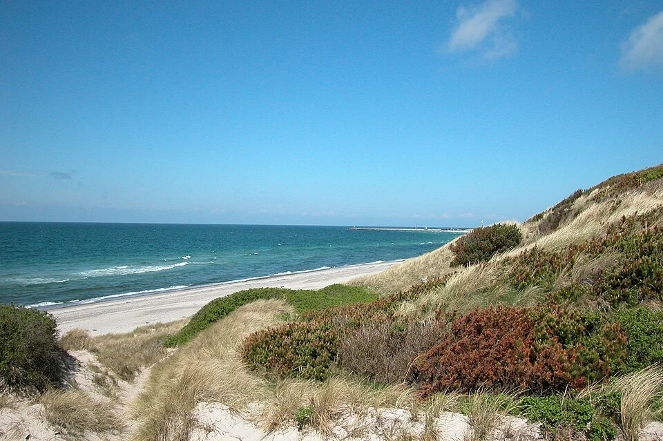
White beaches and low islands between two very different shores. Anholt brings dunes and an open horizon; Læsø brings fishing harbours, salt and extraordinary old houses. Across the water, Swedish bathing villages and fortress towns lead toward the first skerries of Gothenburg.
Kattegat opens north of Sjælland, Fyn and the Danish straits, between Jutland and Sweden. Its northern edge lies approximately along the Skagen–Marstrand line. Anholt belongs to this sea, with Læsø farther north and closer to the Danish shore.
From Copenhagen, Øresund leads through the Helsingør–Helsingborg narrows. From the Belts, the entrance is farther west, around Samsø and Djursland. Those approaches give the same water quite different beginnings: a castle and a busy international strait on one side, low Danish islands and the Jutland coast on the other.
Grenaa to Anholt is roughly 27 nm across open water; Anholt to Varberg about 35 nm. Frederikshavn Marina to Læsø’s Vesterø harbour is around 16 nm. The islands are far enough apart to feel separate, with crossings that can put the mainland below the horizon.
In settled summer weather, Kattegat can be all pale sand, blue-green shallows and an enormous sky. The low Danish land almost disappears into the light. White beaches make the islands look unexpectedly bright after a crossing, while the Swedish shore gives the eye more rock and relief.
The open water can also become uncomfortable quickly, with short, steep seas. Westerly and southwesterly winds have a long fetch toward Sweden; closer to eastern Jutland, the same weather can mean less wave build-up in the lee of the land, even while the wind remains strong. Easterlies change that relationship and expose the Danish shore. The difference between the two sides is often more useful to a cruising boat than a division by country.
Much of western Kattegat is shallow, while a deeper channel follows the Swedish side. SMHI’s sea forecast covers Kattegat, the Sound and the Belts. Anholt and Læsø sit out in the basin: the sea on their approaches need not resemble conditions beside a mainland harbour.
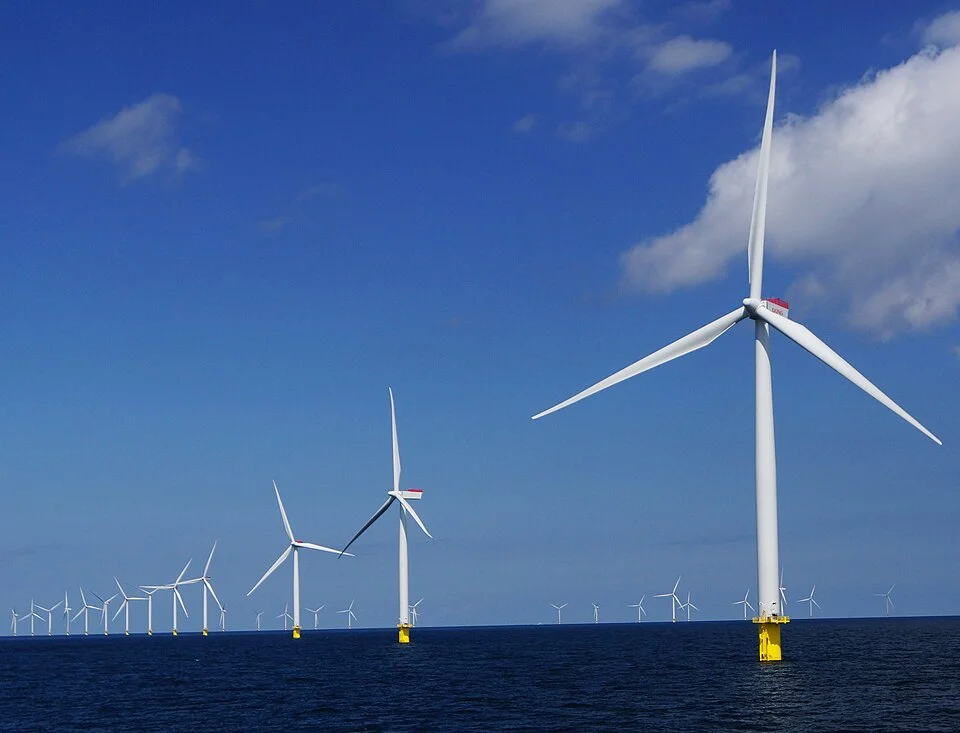
Commercial shipping connects the Baltic with the North Sea, and wind farms add another large-scale presence. Between Djursland and Anholt, the 111 turbines of Anholt Offshore Wind Farm form a conspicuous horizon of their own.
Anholt’s offshore wind farm occupies the water toward Djursland.Photo: Old Dane
Anholt is a destination with a pronounced sense of arrival. After the open-water crossing, a low rim of sand takes shape around the island, followed by the harbour’s breakwaters and masts. The beach begins close to the boats, and the landscape beyond it is much larger and quieter than the busy waterfront suggests.
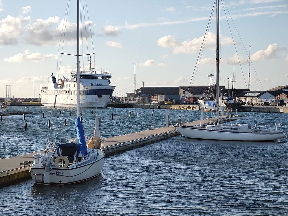
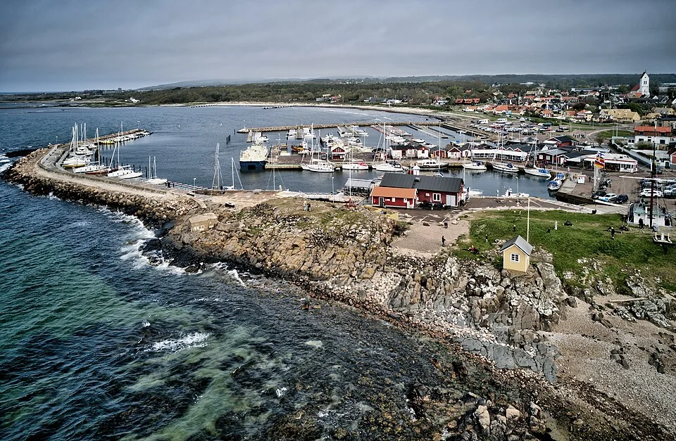
The harbour occupies the northwestern shore. In the summer holidays its pontoons fill with visiting yachts, with provisions, places to eat and the mainland ferry concentrated around this small corner of the island. A change in the weather can keep several crews here together; away from the quays, there is still room for long beach walks and open country.
Anholt village lies inland, separate from the harbour. Its church, houses and small lanes give the island another centre, away from the movement of arriving boats. Bicycles are useful between the harbour, village and western beaches; the great expanse of Ørkenen farther east is walking country.
Yachts and the mainland ferry share Anholt’s harbour.Photo: Fugit hora
The inhabited western end and the open eastern landscape are close on the map but feel quite different underfoot. The village sits behind the higher western ground; beyond it, low heath and beach ridges stretch toward the lighthouse.
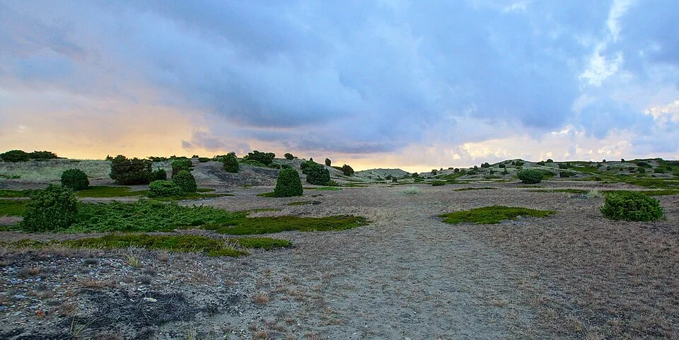
Ørkenen means “the desert”, but its character is northern: low heath, pale sand, old beach ridges and small, wind-shaped plants. Juniper and heather interrupt the open ground, with dune hollows and the sea appearing between them. The scale comes from the unbroken landscape and the low horizon, rather than great hills.
The local landscape guide describes slow-growing vegetation and traces that remain visible for years. Cars, bicycles and golf carts are not permitted in the protected heath. This is the part of Anholt to explore on foot, along the existing paths and the long beaches.
Anholt Fyr stands near the eastern end, its red-and-white tower a strong vertical line in the low landscape. The lighthouse buildings themselves are not open for ordinary visits. Beside them, a viewing shelter with a telescope looks toward the seals at Totten.
The Totten seal reserve closes the eastern tip and the adjoining water to access throughout the year. The shore observation point allows a view without entering the colony; the restriction also rules out approaching the seals by dinghy, kayak or paddleboard. Beyond this small protected corner, the island’s long beaches remain one of its great pleasures.
Ørkenen: low heath, sand and a wide sky.Photo: Old Dane
Læsø spreads low across northern Kattegat, with beaches, heath and a settled interior that rewards leaving the waterfront. Its two harbours sit on different sides of that island life: Vesterø faces the Danish mainland, while Østerby opens onto the north coast and retains a strong fishing presence.
At Vesterø, the ferry and yachts arrive beside shops, fishmongers and places to eat. A sandy beach runs south from the harbour, so a swim or a walk along the shore begins close to the boat. The road inland reaches Byrum, the island’s main town, and continues toward Østerby. Bicycle hire near the harbour and the bus across the island make the interior accessible without moving the yacht.
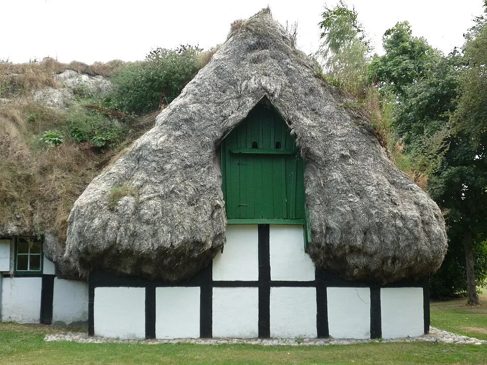
The great, heavy roofs of the old tanghuse are Læsø’s most distinctive buildings. Their thatch is eelgrass, gathered from the sea, laid so thickly that it gives the houses an almost sculpted outline. The walking routes around Gammel Østerby pass restored examples, including the area around Hedvig’s House.
South of Byrum, Læsø Salt brings the island’s old salt-making industry into view. The saltworks offers talks about the process and, seasonally, small pans where visitors can try making salt themselves. It is a concrete, hands-on excursion alongside the beaches and village walks, with the operator publishing the programme for each part of the season.
Hedvig’s House, with Læsø’s distinctive eelgrass roof.Photo: Hartmut Schmidt Heidelberg
Food shops, restaurants and marine businesses surround the port. The bus leaves from the harbour square for Byrum, about 7 km away, and Østerby, around 20 km away; the ferry connects with Frederikshavn.
Fish businesses and boat services give it a different emphasis from Vesterø’s ferry waterfront. It is also closer to the old eelgrass-roofed houses around Gammel Østerby. These are total marina capacities, rather than dedicated visitor-berth counts.
Grenaa is the natural mainland counterpart to Anholt: a substantial port and a place for supplies, services and ferry connections to the island. The yacht marina lies south of the commercial harbour, beside the beach. Keeping those two entrances distinct matters; the yacht facilities and their approach information belong to Grenaa Marina.
North around Djursland, Bønnerup combines fishing activity with visiting yachts. Fishing boats, boat businesses and fish shops are part of the waterfront, rather than a decorative memory of an earlier port. Beaches lie close by, and the low coast continues toward eastern Jutland’s more widely spaced harbour towns.
This shore offers a different relationship with the open basin from Sweden’s west-facing coast. In westerly weather, the land can take much of the wave fetch out of a coastal passage. Its harbours also have reasons to visit ashore: the smaller fishing-port setting at Bønnerup, Sæby’s old streets, and Frederikshavn’s broader range of services and transport.
Marina info
Grenaa Marina
Entrance silting is a material constraint: the 21 April 2026 depth notice and survey report reduced depths, especially near the green entrance light. Use the marina’s current survey and harbour office for the entrance depth; its nominal depth is not a reliable substitute.
The marina’s arrival page describes floating-pontoon berths between piles, with the eastern quay reserved for boats over 14 m alongside.
Bønnerup’s visitor information covers berths, payment and harbour facilities. The port brings a marina and an active fishing harbour together, with a shipyard and slipway among its services. The harbour guide connects the boat facilities with fish shops, places to eat and the nearby shore.
Sæby’s harbour sits where the small river meets the sea, close to the town’s older streets.
The mainland ferry connection to Læsø departs from Frederikshavn’s ferry port.
The northern end · Skagen
A fishing town in the painters’ light
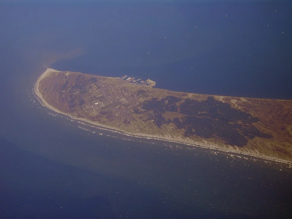
Skagen gives the Danish side a strong northern destination. The fishing harbour is substantial, the yacht waterfront busy in summer, and the town’s yellow houses stand between broad sandy shores. Beyond the streets, the peninsula narrows toward Grenen, where Kattegat meets Skagerrak.
The town’s artistic history grows directly out of this setting. Skagens Museum holds the work of the painters who gathered here, including Anna and Michael Ancher and P. S. Krøyer. Fishing, domestic interiors and the light over beach and sea make the museum a particularly apt visit from the harbour.
At Grenen, the shifting sand and meeting waves make the end of the peninsula visible in a way a map cannot. It is a shore excursion from town; bathing at the point is prohibited because of the currents. From the yacht harbour, the wider choices extend toward northern Jutland, the Swedish islands and the crossing to Norway.
The sandy end of Jutland at Skagen, seen from the air.Photo: BjørnN
The southeastern entrance · Helsingør and Helsingborg
Kronborg at the doorway
At Helsingør, Kattegat gathers into the narrow Sound. Kronborg stands beside the passage, Sweden is only about 2 nm away, and ferries cross between Helsingør and Helsingborg through the north–south traffic. The current here can make the change from the open basin to Øresund quite pronounced.
Helsingør is worth a visit for the castle, the old town and the maritime museum in the former shipyard dry dock. The northern Øresund guide develops the town and the Danish coast toward Copenhagen.
Northward on the Swedish side, the Kullen headland and Bjäre peninsula give the open coast its shape. The smaller-scale island shelter associated with Bohuslän is still farther north; here, village harbours punctuate longer stretches facing Kattegat.
The Swedish shore · Bjäre peninsula
Torekov’s small harbour world
Torekov has the compact form of an old maritime village and the lively summer life of an established holiday place. Houses gather close behind the harbour, restaurant tables face the waterfront, and bathing is part of the daily rhythm. It is polished and sociable, but the old harbour still provides its centre.
The Morgonbryggan bathing pier expresses that local character particularly well: the morning swim has its own place beside the village. Rocky shore, bathing ladders and nearby sandy beaches offer several ways to spend time by the water without going far from the boat.
Hallands Väderö sits offshore, with a passenger boat connection from the harbour. Its wooded and rocky outline gives Torekov a more enclosed outlook than much of the coast north toward Halmstad. The island and the village belong together in the view from the quays, even when the yacht stays in harbour.
Torekov’s harbour sits close to the village and bathing shore.Photo: David Castor
The Halland coast has longer open stretches and fewer closely packed islands than the country around Gothenburg. The stops are more widely spaced, with beaches, river mouths and towns giving each its setting. Halmstad and Falkenberg bring useful choices between Torekov and Varberg.
Halmstad’s three guest harbours offer quite different visits. The city harbour on the Nissan is near the centre, with a view toward the castle. Grötvik sits beside old stone quarries and the coastal Prince Bertil’s trail; Skallkroken is farther north, close to Haverdal’s beach, dunes and woodland. The distinction is the shore outside the berth: town life, a coastal walk or a quieter beach landscape.
The Swedish shore · Varberg
A fortress, a town and a berth close to both
Varberg makes a substantial landfall from Anholt or a rewarding stop along the Swedish coast. The inner harbour brings the boat close to the town, while the fortress dominates the shore nearby. After exposed water, the enclosed basin and short walk into the centre change the scale of the visit immediately.
The waterfront holds several layers of the town together: working-port history, visiting yachts, bathing and the massive fortifications. Shops and restaurants sit within reach of the harbour. A walk around the fortress gives a wide view back over Kattegat and the water crossed to reach it.
Varberg’s fortress was developed into a major defensive work while Halland belonged to Denmark. The region passed to Sweden in 1645, giving the place a history that crosses the modern line between the two shores. The fortress grounds can be visited freely; the museum exhibitions inside require a ticket. The ramparts alone make a good shore walk, with a fuller historical visit available under the same roofline.
Toward Gothenburg · The first skerries
Where the Swedish coast becomes an archipelago
North of Varberg, smaller harbours continue along the coast before the islands gather around Gothenburg. The change is gradual and then unmistakable: more rock, more channels, inhabited islands and smaller stretches of open water between them. The broad Kattegat horizon begins to share the view with close granite shorelines.
The Gothenburg–Smögen guide explores the southern archipelago, Marstrand and the village harbours around Orust. Skagen remains across the northern water, while Læsø sits off the Danish side. These places connect across Kattegat as well as along their national coastlines.
From Skagen, Skagerrak to Stavanger explores the crossing and the Norwegian coast beyond it. The Western Norway overview connects those approaches with the island waterway towards Bergen.
Map data and licence notices
Coastline extract from GSHHG 2.3.7 by Paul Wessel and Walter H. F. Smith: regional GeoJSON, dataset notice, LGPL and GPL. Map composition: sol.blue.