Denmark · A capital on the water
Copenhagen by yacht
Canals and old ships, harbour baths and bicycle bridges: a city whose waterfront is part of everyday life.
Find your part of the waterfront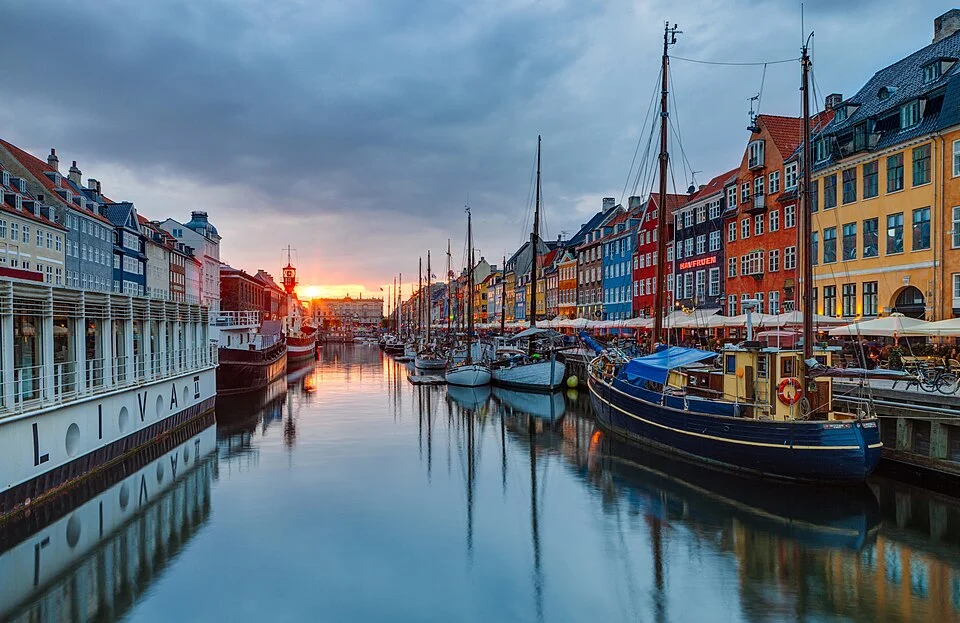
Photo: Moahim
Copenhagen gives arriving by boat a particular pleasure. Beyond the outer port, the water becomes a city space: the opera house on one bank, quays and squares on the other, canal mouths opening between old warehouses. People cross above the water on foot and by bicycle, sit along its edges and swim in designated harbour baths.
A central berth makes that waterfront part of life aboard. Dragør, Kastrup and Tuborg offer different surroundings, with public transport into the centre: an old seafaring town, an Amager beach coast and a modern northern marina. The choice changes what lies immediately outside the boat, while leaving the wider city within reach.
The city’s geography
Amager, the central harbour and the northern shore
Map: sol.blue · Coastline: GSHHG 2.3.7, LGPL 3 or later.
Copenhagen’s central harbour separates Sjælland from Amager. Dragør stands at Amager’s southeastern corner, with Kastrup farther north on the island’s east coast. Tuborg lies beyond the city’s northern port, on the Danish shore of Øresund.
For a visit centred on Copenhagen itself, Langelinie or a berth in Christianshavn brings the streets and waterfront close to the boat. For a convenient stop while passing through the Sound, the outer harbours fit the geography more directly: Amager from the south, Tuborg from the north.
A masted yacht reaches the central harbour from the northern entrance. The waterway south through the city has fixed bridges with only about 3 m clearance at normal water level beyond the Sydhavn lock. A berth on Amager’s east coast therefore has a different approach from one among the central canals.
Copenhagen proper · Staying among the waterfront streets
A city around the boat
The central harbour gives a visit continuity between boat and city. A walk ashore can follow the water into a square or across a bridge; an evening out ends at a berth within the same neighbourhood. Langelinie offers an open waterfront beside the Little Mermaid and Kastellet. Christianshavn places the boat among canal walls, moored vessels and old streets on the opposite side of the harbour.
These settings come with different berth arrangements. Langelinie uses vacant resident spaces; a canal marina may accept a reservation and require an opening bridge. Nyhavn’s photogenic ships and restaurant quays are a place to visit ashore, rather than evidence of an available visiting berth.
Langelinie to Nyhavn · The western waterfront
Ramparts, royal squares and old ships
Langelinie begins with a contrast: the busy little patch of shore around the Little Mermaid and, just behind it, the grassy ramparts of Kastellet. The star-shaped fortress remains an active barracks, surrounded by a public park. Its paths and moat give the northern waterfront a spacious, green edge before the denser streets begin.
South along the harbour, the city becomes more formal around Amalienborg, then more theatrical around the Royal Danish Playhouse and Nyhavn. Across the water stands the broad roof of the opera house. The quays here make the relationship between city and harbour easy to see: royal buildings, cultural venues and everyday walking space all facing the same water.
Nyhavn is colourful and busy, with traditional vessels beneath rows of narrow houses. The canal’s former port life survives in the ships and buildings, while restaurant terraces and sightseeing boats supply most of the present movement. It is a good place to linger over the harbour scene; the smaller streets around it lead back into the centre when the quays feel crowded.
Beyond the immediate waterfront, Copenhagen has another scale of visit: the streets around Kongens Nytorv, gardens and museums, food halls and the old centre’s squares. The city-centre guide gathers the main sights. A central berth makes it easy to move between these places and the water without turning every outing into a transport journey.
Across the inner harbour · Canals and islands
Christianshavn at walking pace
Christianshavn changes the proportions of the waterfront. The great open harbour gives way to canals, with masts close to upper-floor windows and bicycles passing between the water and the houses. Old warehouses, coloured façades and small quays make this one of the most rewarding parts of Copenhagen to explore without a fixed destination.
Its bridges connect that smaller world with the city centre. Inderhavnsbroen links the Nyhavn side with the area around Broens Street Food, where food stalls and outdoor tables face the harbour. Farther into the neighbourhood, the canal streets and the spire of Our Saviour’s Church give a different view from the broad city quays.
Holmen opens out again toward the opera house and former naval waterfront. Back inland, the old Christianshavn ramparts follow green banks and water. The variety lies in how close these settings are: a working canal, a grand harbour building and a wooded path can all belong to the same walk.
The Christianshavn neighbourhood guide is useful for its smaller venues and current places to eat. A berth here brings local street life close to the cockpit, while an outer marina still leaves the district readily accessible by metro.
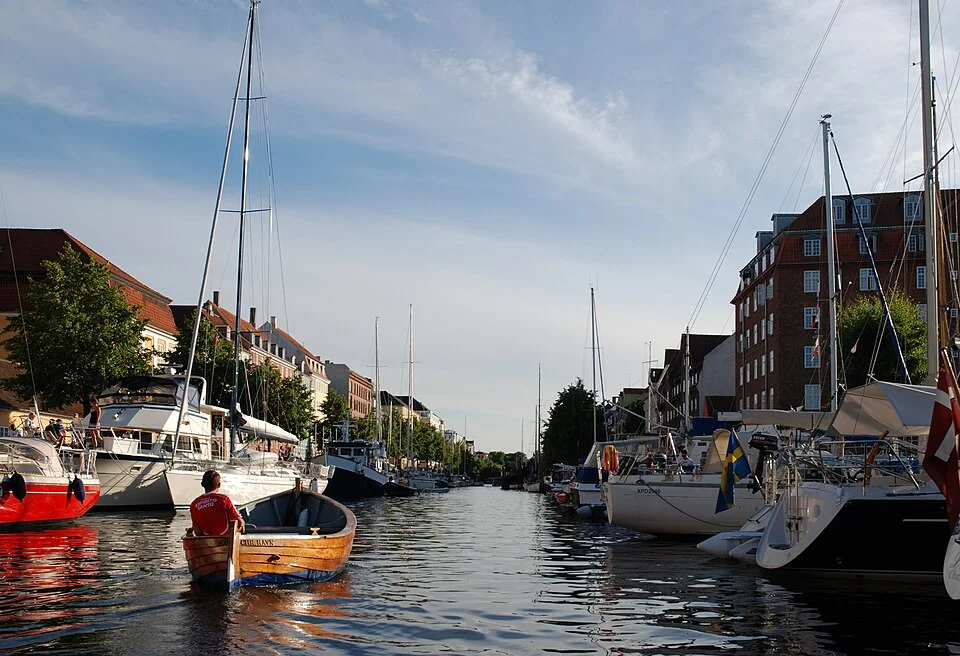
Photo: Bob Collowan
Southeastern Amager · An old seafaring town
Dragør: yellow houses behind the harbour
Dragør has its own reason to draw a boat south of Copenhagen. Low yellow houses, red roofs and narrow lanes gather behind a harbour whose pilot tower and small waterfront buildings retain the proportions of an older port. The change from quay to town is immediate.
Its maritime history runs from medieval herring trade to the sailing ships of the eighteenth and nineteenth centuries. Much of the old town belongs to that later period. The harbour’s account of Dragør connects the surviving waterfront with trading ships, pilots and fishing. Walking the lanes gives that history a domestic scale: small houses and courtyards behind a port that once reached much farther afield.
Dragør works equally as a town visit and as a southern foothold for Copenhagen. Bus connections reach the city and airport, so the boat can remain beside this quieter old centre while the crew explores the capital. Rejseplanen gives the appropriate connection from the harbour area.
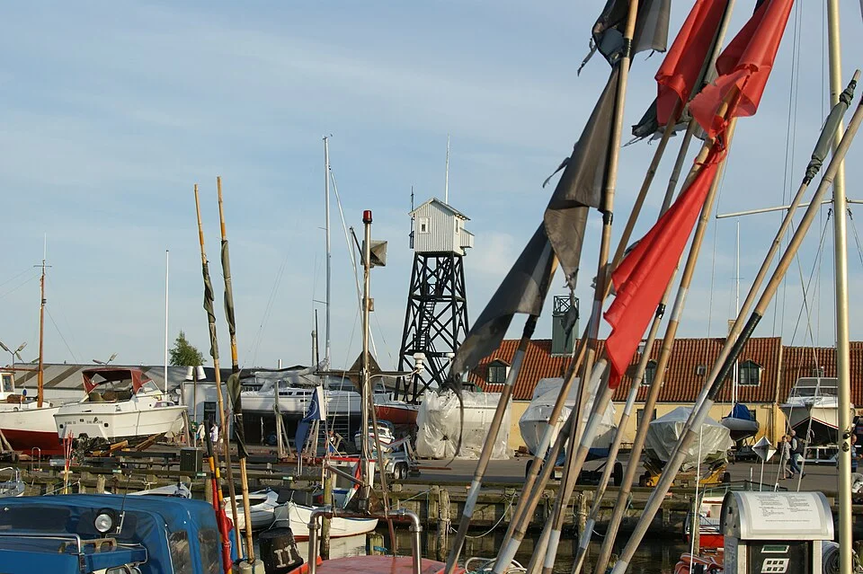
Photo: Jens Cederskjold
Eastern Amager · Beaches and the metro
Kastrup: room to spread out ashore
Kastrup is a larger, more open marina setting. The coast here has beaches, bathing facilities and recreational space, with the city reached inland by metro. For a boat approaching from the southern Sound, it offers a straightforward geographic relationship between the passage, the berth and a visit to Copenhagen.
The shoreline is worth time in its own right. Kastrup Strandpark and the sculptural timber enclosure of Kastrup Søbad give the waterfront a bathing and outdoor character. Farther south stands Den Blå Planet, Denmark’s national aquarium. The aquarium is a substantial shore attraction close to the water, with its own metro access and visiting information.
Amager Strandpark continues the beach landscape northward. This is a different backdrop to a city stay from Nyhavn or Christianshavn: open shore, swimming and room for a long walk, followed by a train into the centre. The metro stations are inland from the waterfront, so the walk from the chosen basin is part of the connection.
North of the central port · Hellerup
Tuborg: a modern waterfront beside the Sound
Tuborg offers another version of Copenhagen’s waterfront: contemporary buildings, broad marina basins and the Royal Danish Yacht Club. It lies north of the central port, well placed for the Danish coast toward Rungsted and Helsingør. A berth here gives access to the city without taking the boat through to the inner harbour.
The former industrial waterfront now has shops and restaurants around the Waterfront centre, with Strandvejen behind. Experimentarium, the interactive science centre, is only about 300 m from the yacht club. It adds a substantial indoor outing close to the berth. Hellerup’s beach and the coast northward bring the more open, residential shore into reach as well.
Across Copenhagen · Life ashore
Bicycles, trains and a swim in the city
The boat’s address need not determine the limits of a city visit. Copenhagen’s metro runs around the clock, while buses and trains connect the outer waterfronts. Rejseplanen combines the modes for a particular journey, including the walk between a marina and its nearest stop.
A bicycle connects the waterfront districts at a more revealing pace. Bridges bring Christianshavn close to the centre, and the coast offers a longer line of travel toward the beaches. Conventional hire shops and app-based rentals offer alternatives to carrying bicycles aboard.
Swimming belongs to the city too. Islands Brygge’s harbour bath and the bathing area at Sandkaj in Nordhavn offer urban settings; Amager has the broader beach landscape. Copenhagen’s designated baths and beaches distinguish those places from the working waterways. A harbour visit can combine museums and streets with time at the water’s edge, even when the boat stays in its berth.
Neighbouring cruising grounds
Both sides of a Copenhagen visit
To the south, Møn and the southern approach bring chalk cliffs, beech woods and Klintholm’s working harbour. To the north, the Strandvejen coast connects Rungsted, Karen Blixen’s home and Helsingør. Return to the Baltic & Skagerrak map for the wider geography.
Map data and licence notices
Coastline extract from GSHHG 2.3.7 by Paul Wessel and Walter H. F. Smith: regional GeoJSON, dataset notice, LGPL and GPL. Map composition: sol.blue.