Denmark · The southern approach to Øresund
Møn & the waters toward Copenhagen
White cliffs and beech woods, a small working harbour, and open Baltic water leading into one of Europe’s great maritime passages.
Explore Møn and the southern Sound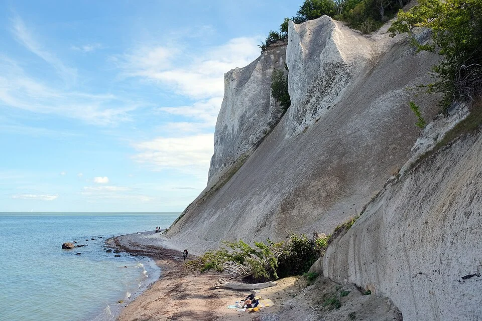
Photo: kallerna
Møn gives this stretch of Danish coast its great landmark. Chalk rises above the sea in long, broken walls, with dark seams of flint and a fringe of woodland along the top. Around the island’s southeastern corner, Klintholm Havn brings the scale back down to fishing boats, yacht pontoons and beaches on either side of the harbour.
Between Møn and Copenhagen, the water opens out. The coast recedes, ships move along the Baltic approaches, and the low shores of Amager eventually replace the cliffs. These are two quite different pleasures within the same cruising ground: time ashore in an extraordinary landscape, and the long views and movement of a passage toward a city. Approached from the north, Møn is the point where the city gives way to countryside and chalk.
The cruising ground
A cliff coast, then a broad approach
Klintholm lies on Møn’s southern shore, west of the cliffs. North of Møn, the Danish coast runs past the broad Faxe and Køge bays toward Amager. Copenhagen occupies the water between Amager and Sjælland; Sweden lies across Øresund to the east. Klintholm to Dragør is roughly 45–50 nm by an offshore passage east of Møn, with Copenhagen’s northern harbour entrance farther on around Amager.
Møn to Amager
Maps: sol.blue · Coastline: GSHHG 2.3.7, LGPL 3 or later.
Southeastern Møn · Harbour and shore
Klintholm: a working harbour with sand on both sides
Klintholm is a modest place beside a much larger landscape. The fishing and commercial basins remain part of its everyday life, alongside visiting yachts and the cafés and restaurants around the waterfront. It suits a meal ashore, basic shopping and a walk along the sand as much as an excursion up to the cliffs.
The beaches begin on both sides of the harbour. They give a visit an easy shoreward direction: the quays and boats behind, low dunes and Baltic water ahead. Away from the waterfront, lanes climb into eastern Møn’s farmland and wooded hills. The cliffs are a separate outing from the harbour, rather than a short promenade at the end of a pontoon.
The harbour lists bicycle hire, useful for reaching the landscape inland. The road approach to the GeoCenter crosses hilly country; for bus connections, Rejseplanen gives the service for the actual travel date. GeoCenter Møns Klint is the useful destination name when arranging transport.
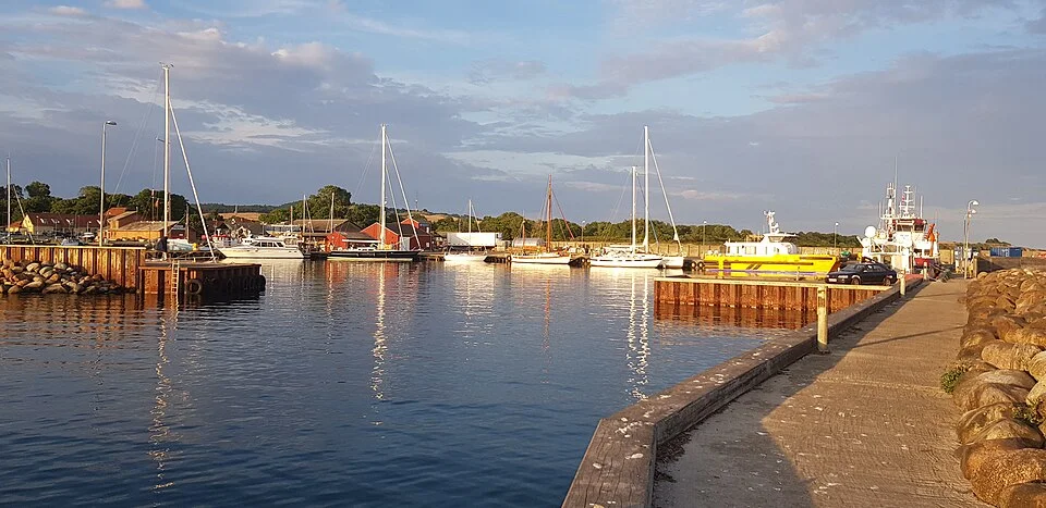
Photo: Kht83
Eastern Møn · Chalk and the Baltic
Møns Klint, from the sea and from above
From offshore, Møns Klint is a sequence of pale headlands and shadowed recesses, topped by trees. The highest faces rise more than 120 m above the water. From this distance the coastline’s shape is clear: a long, steep edge to a rolling island, with a thin beach beneath it. Fine chalk in the water can turn the shallows a milky turquoise.
Ashore, the scale becomes more intimate and more vertical. Paths follow the wooded rim, while long stairways descend to flint pebbles and chalk fragments at sea level. Dronningestolen, the “Queen’s Chair”, rises 128 m above the beach. The view down through the beech canopy and the view back up from the shore belong to the same landscape, but feel very different.
The chalk began as sediment on a Cretaceous seabed. Much later, glaciers pushed and folded great slabs of it into the hills and cliffs visible today. Black bands of flint expose those folds within the white rock. This exceptional record of the forces of ice underlies Møns Klint’s UNESCO World Heritage inscription in 2025.
The coast is still changing. Falls of chalk and larger landslides affect the beach and access routes; the cliff foot is an eroding shore, not a landing place for a visit. Klintholm provides the harbour connection, and the GeoCenter’s walking routes connect the forest, viewpoints and stairways. The 2.3 km Fossil Route includes the beach and a substantial climb back up; staying on the upper paths gives a different visit without that descent.
Møn · A prehistoric trading landscape
The black stone inside the white cliffs
Flint gives the cliffs a human history as well as a geological one. The hard, dark stone could be worked into sharp blades, axes and weapons. For prehistoric communities it was an essential material for hunting, harvesting, clearing woodland and making things from timber. High-quality flint from Møn travelled far beyond the island through trade networks extending north and south across Europe.
The timescale is the Neolithic and Bronze Age world, many thousands of years before the present harbour. The sea was already connecting this coast with distant communities, and one of its valuable commodities came from the cliffs themselves. Looking from a yacht at the dark seams in the chalk puts those old connections back into the landscape.
The GeoCenter’s flint exhibition develops that story through the material and the objects made from it. It adds a human dimension to a visit otherwise dominated by cliffs, fossils and ice: how a piece of stone became a tool, a weapon or an object worth exchanging.
Møn’s burial monuments carry the story inland. The wooded hills near the cliffs contain numerous burial mounds; farther west, stone-built tombs stand in the farming landscape. Klekkendehøj and the other western Møn passage graves belong to a wider island excursion. Closer to the cliffs, Timmesø Bjerg combines old beech woodland with prehistoric earthworks. These are different places, but together they make Møn’s long human occupation tangible.
Behind the cliffs · Klinteskoven and Liselund
Beech woods, chalk grassland and a garden by the sea
Klinteskoven spreads over folds of ground behind the coast. Steep wooded hollows alternate with higher paths and openings toward the sea. Walking here gives Møn another character beyond the white cliff face: bark, leaf shade, damp valleys and sudden bright views between the trees.
The chalk also shapes what grows above it. The open slopes around Høvblege and Jydelejet support distinctive grassland and wild orchids. They bring long views and open sky into a landscape that can otherwise feel enclosed by the forest. The Danish Nature Agency’s area guide connects the viewpoints, woodland and grassland walks.
At the northern end, Liselund changes the mood again. Its late-eighteenth-century landscaped garden has lawns, water, specimen trees and small buildings arranged around a thatched country house. Where the cliffs expose the force of natural processes, this is a deliberately composed landscape. It makes a quieter shore visit, with paths and garden views rather than the steep descent to the beach.
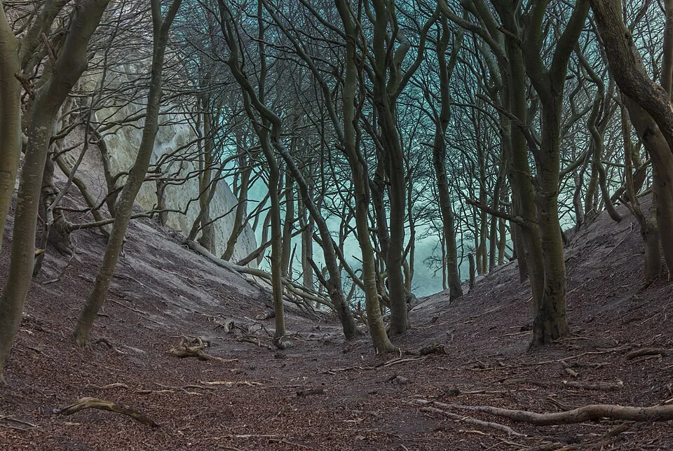
Photo: Slaunger
Between Møn and Amager · Open water
A coast connected to the wider sea
North of Møn, long horizons replace the close succession of cliffs and wooded slopes. The Danish shore opens into broad bays; the passage toward Amager gradually joins the movement of Øresund. Merchant ships, ferries and yachts belong to the same view, with the city appearing by degrees rather than through a sudden narrow gateway.
Current is a meaningful part of the sailing here. Øresund connects the Baltic with Kattegat, and its flow responds to changing water levels, wind and pressure. A favourable stream can add noticeably to progress; wind against current can change the sea as well as the time a passage takes. The useful local reference is DMI’s Øresund ocean forecasts, which include surface current, wind-driven current and sea level.
The commercial traffic has an established structure. The Danish Maritime Authority’s traffic-separation information describes the Sound’s arrangements. Shipping gives these waters their international character, alongside the smaller-scale life of the Danish coast.
Southern Øresund · Amager
Dragør, then the city waterfront
Dragør gathers yellow houses, small lanes and an old pilot and trading harbour on Amager’s southeastern corner. It is a destination in its own right: compact, low-built and close to the sea, with Copenhagen accessible by bus. Farther north along Amager’s eastern shore, Kastrup offers a larger modern marina beside beaches and the metro connection into town.
Copenhagen’s central harbour lies on the other side of northern Amager, with yacht access from the north. A berth near Langelinie or among Christianshavn’s canals puts a different city around the boat: waterfront walks, cafés, bridges and old warehouses. The Copenhagen guide brings together the city neighbourhoods, these harbour choices and the current entrance arrangements.
Neighbouring waters
Around the Baltic and through the Sound
Beyond Copenhagen, northern Øresund follows the beach coast to Rungsted and Helsingør. To the west, Fyn and South Funen offer the closer geography of islands and straits. The Baltic & Skagerrak map places these waters together.
Map data and licence notices
Coastline extract from GSHHG 2.3.7 by Paul Wessel and Walter H. F. Smith: regional GeoJSON, dataset notice, LGPL and GPL. Map composition: sol.blue.