Hirtshals
Hirtshals faces directly onto Skagerrak. It is a practical western departure point for the Norwegian landfalls, within a much larger working port.
Western Norway · The southern approaches
River harbours and old outports give way to the open beaches of Jæren, then to islands, deep sounds and Stavanger’s busy waterfront. Between northern Denmark and western Norway lies a succession of very different coasts.
The geography · Skagerrak, Sørlandet and Jæren
Across Skagerrak, northern Jutland’s dunes and pale beaches face a Norwegian shore of rock, wooded islands and hills. Yachts arriving from the east meet the same southern coast after the outer Oslofjord and Sørlandet. Around Mandal and Lindesnes, these approaches converge before the coast turns towards the North Sea.
West of Lindesnes, the land remains rocky and deeply indented. Hidra, Flekkefjord and Egersund sit within that landscape. Jæren’s low farmland and open beaches begin farther north, around Egersund and Sirevåg, and extend towards Tananger. Here there is much less offshore island shelter. Beyond Tananger, channels and islands reappear around Stavanger, with Ryfylke opening inland.
The same contrasts are just as marked southbound: the fjord country gives way to a long western horizon, then to the small harbours and white wooden towns of the southern coast. These places reward a stay in their own right, whether the next move is along Norway or across to Denmark.
Map: sol.blue · Coastline: GSHHG 2.3.7
Across the sea · Northern Jutland to Norway
Skagerrak is a familiar crossing in Scandinavian summer sailing. Skagen draws Norwegian boats south; Kristiansand and Mandal receive boats coming north from Denmark. For part of the passage there is simply sea around the boat, a distinct change from the close sequence of islands and harbour towns in the Danish and Swedish cruising grounds.
Hirtshals–Kristiansand is roughly 70 nm, and Hirtshals–Mandal about 85 nm. From Skagen the straight-line distances are about 85 and 100 nm respectively, with the rounding of Grenen and harbour approaches adding to the sailed distance. The scale is substantial enough for a changing sea state to matter: there is no intervening island chain, and wind, swell and current can produce a short, uneven sea. The open crossing has a different character from the sheltered water at either end.
The Norwegian landfall is part of its appeal. Low sand gives way to a dark, broken horizon, then rocky islands and wooded slopes. In the other direction, Denmark resolves into dunes, beaches and a much flatter sky. The two shores make the crossing feel like a passage between distinct cruising worlds.
Hirtshals faces directly onto Skagerrak. It is a practical western departure point for the Norwegian landfalls, within a much larger working port.
Skagen lies on the Kattegat side of northern Jutland, with the rounding of Grenen between its harbour and the open crossing westward. The municipal yacht harbour sits beside the town’s busy summer waterfront. Its galleries, streets and northern beaches are covered in the Kattegat guide.
The Norwegian landfall · Kristiansand
Kristiansand provides a substantial city arrival before the coast turns west through the skerries towards Ny-Hellesund and Mandal. Shops, restaurants and the seafront are close to the guest harbour, making it a useful place to exchange the open-water crossing for time ashore.
The old outport · East of Mandal
Between Kristiansand and Mandal, Ny-Hellesund gathers white houses and sheltered water among Monsøya, Kapelløya and Helgøya. The narrow Olavssundet between Kapelløya and Helgøya is its most memorable opening: close rock walls frame a passage into the small harbour world beyond. It is one of several entrances to the outport, rather than an obligatory way in.
The place’s usefulness long predates leisure sailing. Merchant ships sought shelter here; pilots, customs officers, an inn and a school supported the community. Riksantikvaren’s account of the protected outport follows this connection with trade between the North Sea and the Baltic. The scale is intimate today, but its history reaches far beyond the islands.
Olavssundet also carries a coastal legend. St Olav, faced with apparently unbroken land, is said to have sailed on as the mountain opened before him. Stories differ over whether he was racing or escaping pursuers; the narrow gap makes the tale easy to picture. The rock also bears tangible royal marks: monograms of Haakon VII, Olav and Märtha, and Harald and Sonja, described in the local history of Ny-Hellesund.
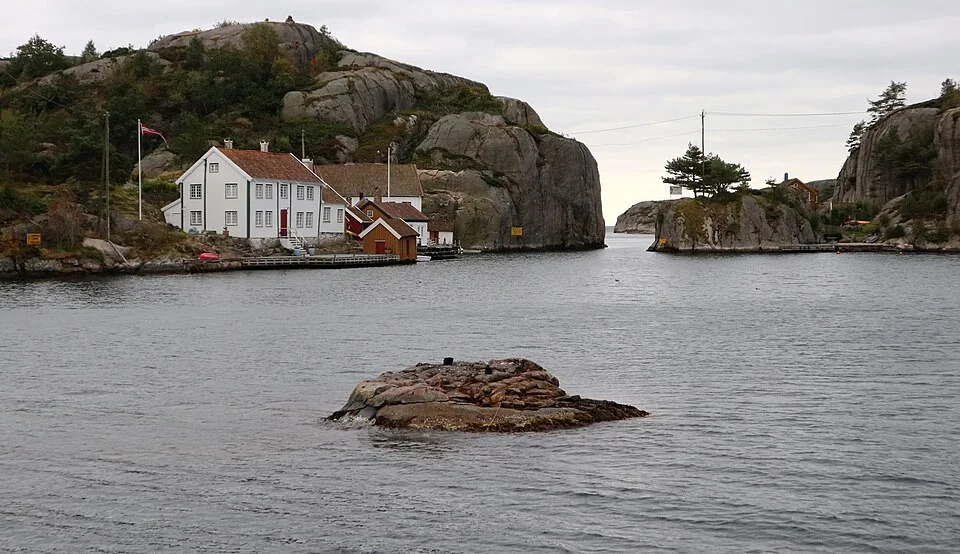
Swimming, walking over the islands and the view from the old pilot lookout belong to the same small landscape. On Kapelløya, Verftet occupies the former boatyard site, with a seasonal café. The pleasure here is the natural harbour and island setting; the town services are back at Høllen or Mandal. The scheduled boat from Høllen also makes an island visit possible from shore.
The river town · Mandal
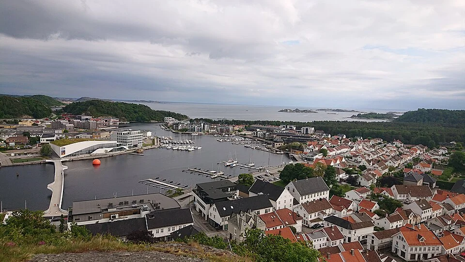
Mandal’s arrival follows the Mandalselva into the town. Quays, houses and streets gather along the river rather than around an isolated marina basin. The setting puts a harbour stay among the daily life of a small southern Norwegian town, with cafés and shops close to the boat.
Behind the waterfront, the older streets retain their white timber houses. Towards the sea, Sjøsanden and Furulunden offer a different shore: an approximately 800 m sandy beach and a network of paths through pine woods to further coves. Beach time and a town walk fit naturally into the same harbour stay.
Mandal is also well placed before the southern corner. Shops and shore facilities make it a comfortable place to remain when conditions outside Lindesnes or along Jæren favour a later departure. The river can have flow, so the experience alongside differs from a still marina basin; the attraction is precisely that the harbour is part of the town and its river.
Norway’s southern corner · Lindesnes
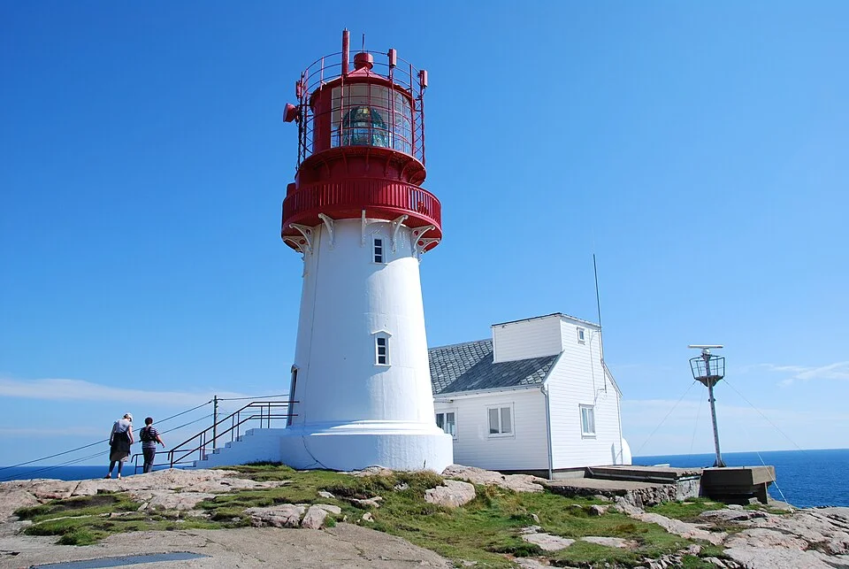
Lindesnes stands above bare rock at the southern end of mainland Norway. Its red-and-white lighthouse marks a long-recognized turning point between the southern coast and the North Sea. The first light was lit here in 1656, making it Norway’s first lighthouse station; the present cast-iron tower dates from 1915.
The lighthouse museum gives the landmark a life ashore, through the work of the keepers, the lights and the coastal service. The tower and rock paths offer a very different view of the exposed corner from that seen while passing it at sea. A museum visit is a shore excursion, separate from rounding the headland by yacht.
There is a small geographical distinction worth keeping: Lindesnes is the southernmost point of the mainland. Kartverket places Norway’s southernmost skerry at Pysen, east of the cape near Mandal. The famous lighthouse and the actual southern extreme are different places.
West of Lindesnes · Hidra and Flekkefjord
The coast west of Lindesnes remains an intricate landscape of headlands, islands and inlets. Hidra’s harbour settlements sit close to the outer coast, while Flekkefjord draws boats farther inland. Their sheltered settings and older waterfronts belong to a different Norway from the open beaches ahead.
On Hidra, Kirkehamn gathers houses around the fishing harbour beneath the white church; Rasvåg occupies another narrow inlet on the island’s southern side. The local island guide describes both communities and their waterfronts.
Flekkefjord brings a fuller town ashore, with the white houses of Hollenderbyen and a street-art collection threaded into its older streets.
Hidra and Flekkefjord also change the distance to the next exposed water. They place a boat farther west than Mandal, with an island or town stay between the southern corner and the approach to Egersund.
The sheltered town · Egersund
Egersund sits inside a substantial natural harbour, with Eigerøya separating much of the town water from the open coast. Fishing and maritime industry remain visible, while the centre keeps the smaller scale of a wooden town. The guest harbour makes that combination accessible directly from the quay.
Strandgaten’s older timber buildings form a coherent streetscape, with much of their present form following the 1843 fire. Dalane Folk Museum’s account of the street explains the rebuilding and its classical details. Cafés, shops and the old town streets are close enough to explore on foot from the waterfront.
Egersund is a useful dividing point in the coastal geography. The southern approaches remain rocky and indented; northwards, the shore opens into the lower landscape around Sirevåg and Jæren. Tananger lies roughly 30–35 nm away in direct geographic terms, with the coastal course adding distance. Egersund and Tananger frame the principal exposed section, with Sirevåg offering another harbour near its southern end.
The open western shore · Jæren
Jæren is strikingly horizontal. Farmland, stone walls, dunes and long beaches replace the island-fringed rock farther south. The western horizon is broad, and North Sea swell reaches the shore with little outer archipelago to interrupt it. In settled conditions it offers expansive sailing; with a developed sea, the same openness dominates the passage.
The distinction is exposure rather than exceptional mileage. Harbour choices are more widely spaced, and the coast offers fewer small sheltered alternatives than the skerries around Mandal or the islands beyond Stavanger. Egersund and Tananger sit at useful opposite ends of this change in character.
The beaches are also destinations ashore. Jæren’s coastal landscape includes broad strands at Ogna, Orre and Bore, with dunes and paths above the surf. Their openness is as apparent on a beach walk as it is from the boat.
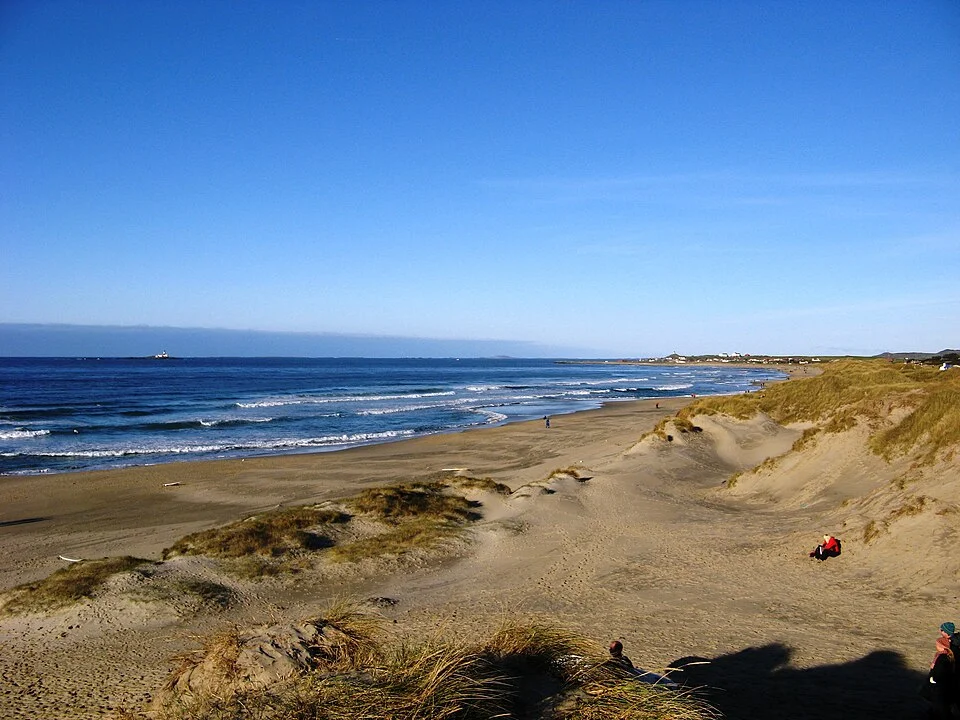
Sirevåg is a working fishing harbour behind a substantial breakwater, close to the meeting of Jæren’s beaches and Dalane’s rock. Ashore, Sannarvågen and the walk towards Ognasanden put the changing shoreline within reach of the harbour.
At the northern end · Tananger and Stavanger
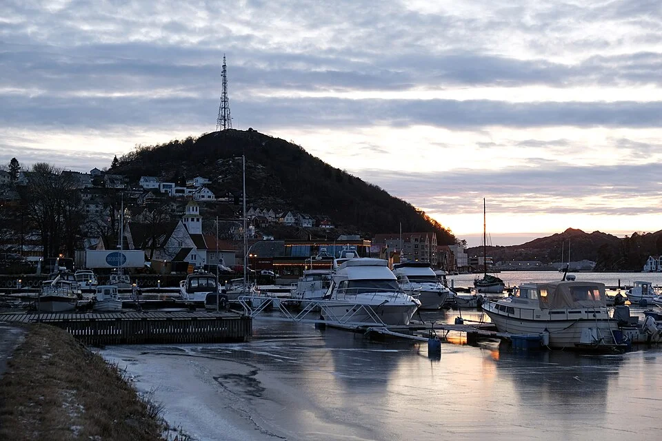
Tananger brings the coast back to a compact harbour setting. Its older maritime life came from pilotage, lobster export and fishing, and fishing boats still use the inner harbour. A coastal collection preserves boats and equipment from that history. The town centre’s shops are around 800 m from the boat association’s harbour.
Tananger is a serviced harbour at the northern end of Jæren, useful on either side of an open-coast passage.
Nearby Risavika changes the scale: ferries, cargo operations and an offshore supply base belong to Stavanger’s wider maritime region. Beyond, islands and channels return around the city. The onward coast no longer resembles Jæren’s long, low edge.
Stavanger offers a city-centre arrival, with old sea houses, restaurants and museums close to the guest berths. North and east, the water opens among the islands of Ryfylke and towards Lysefjord. The transition is visible in both the landscape and the vessels using it: small harbours and beach coast give way to a busy city at the entrance to a much larger fjord world.
Neighbouring cruising grounds
Stavanger and the fjord gateway explores the city’s two central guest harbours and the turn inland towards Lysefjord. Across Skagerrak, Kattegat connects Skagen with the Danish islands and Sweden. The Western Norway map sets the approaches alongside the coast leading north towards Bergen.
Coastline extract from GSHHG 2.3.7 by Paul Wessel and Walter H. F. Smith: regional GeoJSON, dataset notice, LGPL and GPL. Map composition: sol.blue.