Western Norway · City harbours, islands and fjords
Stavanger and the fjord gateway
Stavanger puts the city around the boat: old sea houses, seafood, narrow streets and a working waterfront. Beyond it, the islands of Ryfylke open into deep fjords, with Lysefjord’s cliffs drawing the eye east.
Stavanger sits where the open coastal approaches from Jæren meet an island-and-fjord landscape. Byfjorden connects the city with the sea to the north and west. Rennesøy and Finnøy lie among the islands beyond, while the waterways east of the city lead into Ryfylke and towards Høgsfjorden.
At Forsand, Lysefjord turns northeast from Høgsfjorden into higher, steeper country. Preikestolen overlooks its western part; Flørli occupies a small opening on the southern shore, and Lysebotn sits at the head. The coast towards Haugesund and Bergen lies in another direction, north through islands and broad fjord mouths.
These are distinct cruising landscapes close to the same city. The lower islands offer open views between wooded and cultivated shores. Inside Lysefjord, rock walls close around a narrow strip of deep water. Stavanger provides a lively urban shore between them, with two guest harbours within walking distance of its historic centre.
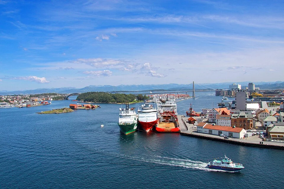
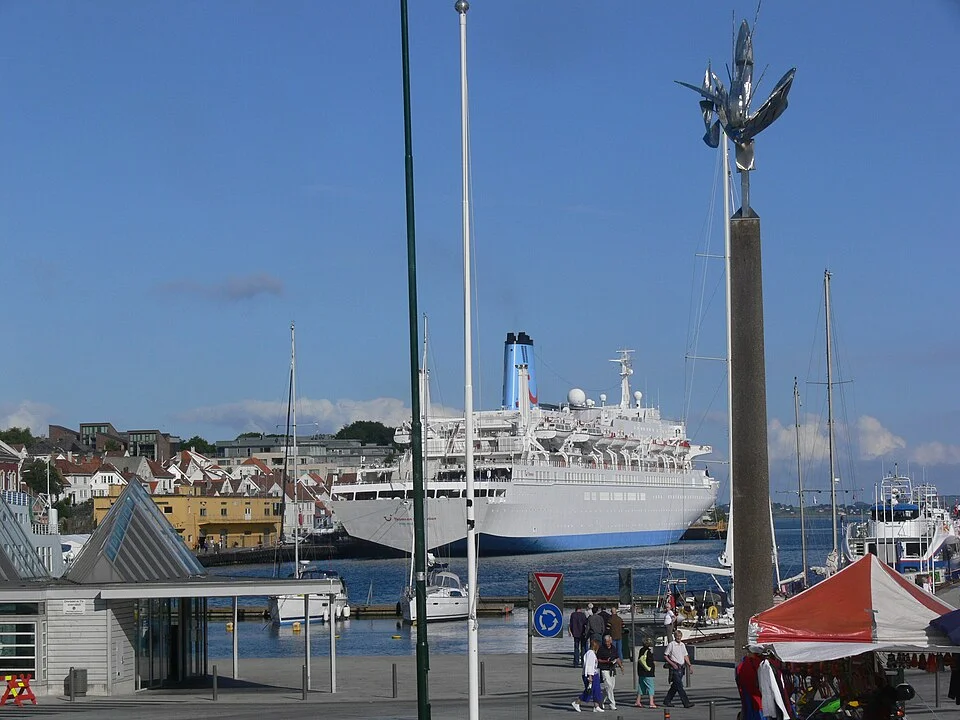
Vågen reaches into the heart of Stavanger. The quays meet the older streets at the head of the harbour, with Gamle Stavanger climbing the western side and the city centre wrapping around the eastern shore. A berth here brings the boat into the city’s public life, close to waterfront restaurants and passing pedestrians.
Børevigå lies just around the eastern headland, beside the Norwegian Petroleum Museum. It keeps the central location but has a quieter setting. The difference is small on a street map and noticeable during a stay: one harbour faces the busiest social waterfront, while the other gives a little more separation from it.
Vågen is a city harbour shared with much larger vessels.Photo: Christian Bickel
Restaurants and nightlife make this the livelier choice. Cruise-ship manoeuvres can bring wash and propeller currents, and festivals sometimes close the guest berths. The port publishes those closures on its harbour page.
The port authority’s guest harbour accommodates around 20 yachts.
Visitor pontoons serve boats up to 15 m; larger boats contact the harbour watch by phone or VHF 12.
Harbour watch+47 51 50 12 01Copy unavailable. Select the number.
Marina info
Børevigå
Børevigå has finger pontoons and water and electricity points. It is only a few minutes’ walk from the centre. Showers, toilets and laundry are in the service building here, which also serves visitors staying in Vågen.
Visitor pontoons serve boats up to 15 m; larger boats contact the harbour watch by phone or VHF 12.
Harbour watch+47 51 50 12 01Copy unavailable. Select the number.
On foot from the quay · Gamle Stavanger
White timber houses and small streets above the harbour
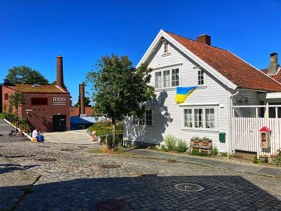
On Vågen’s western side, the lanes of Gamle Stavanger rise behind the waterfront warehouses. White wooden houses, cobbles and small gardens give the hillside a domestic scale, with the harbour repeatedly visible below. The old quarter contains 173 preserved timber houses, principally from the late eighteenth and early nineteenth centuries.
A walk along Øvre Strandgate leads into the neighbourhood and to IDDIS, the printing and canning museums. The buildings still sit within a lived-in part of the city. Their close relationship with the working harbour is easier to appreciate on foot than from a distant view of Stavanger’s skyline.
Across Vågen, the centre has another mood. Øvre Holmegate, usually called Fargegaten, brings brightly painted façades, cafés, pubs and small shops together along one street. The municipality’s introduction to Stavanger places this colourful street alongside the old wooden quarter and the modern energy city.
Gamle Stavanger’s lanes lead from the waterfront into the old wooden quarter.Photo: Artem Vynohradov
Stavanger’s sea houses make more sense with the fishing and trading history behind them. The Maritime Museum’s “From herring to oil” exhibition follows the city from the nineteenth-century herring fisheries through shipbuilding and international shipping to offshore energy. Local boat models and material from passenger ships connect the wider industrial story with life on the coast.
IDDIS brings two related trades together: canning and printing. The canning museum occupies a former factory, while the printing museum explains the machines and skills behind the labels and other printed work. Iddis is the local word for a label, especially one on a tin. The colourful packaging makes a concrete link between food, manufacturing and the city’s graphic industry.
Beside Børevigå, the Norwegian Petroleum Museum addresses the more recent offshore chapter. The supply vessels and port infrastructure seen around Stavanger and Risavika belong to that same story. The city’s maritime past is still visible in the work taking place along its shores.
Food returns the visit to the waterfront. Fisketorget has both a seafood counter and a restaurant at Vågen, so it works for a meal ashore or fish to take back aboard. Fargegaten’s cafés offer a change from the quays, and the compact centre puts food shopping and the museums within the same walking area.
Beyond the city · Ryfylke
Islands first, then the higher fjord country
Ryfylke begins close to Stavanger, but its landscape is much broader than the famous cliff photographs suggest. Rennesøy, Finnøy and their neighbours form an island country of sounds, cultivated land and sheltered shores. Farther east and north, the water branches between higher slopes into the fjords.
The regional introduction to Ryfylke brings together this range: islands, orchards, small settlements, waterfalls and mountain country. The lower shores retain a green, inhabited character. The high inner fjords have fewer settlements and much steeper boundaries between land and water.
That change affects time under sail. Open sounds give room for a breeze to develop, while enclosed reaches can be still, funnel wind along their length or receive sudden gusts from the slopes. A passage into the high fjords may involve considerably more motoring than an outer-coast sail. The landscape is the attraction, with the wind strongly shaped by the terrain.
The branch east · Lysefjord
A long reach beneath the cliffs
Lysefjord runs about 42 km inland from Forsand, between rock walls that rise more than 1,000 m in places. Its pale granite gives the fjord its name. The water deepens beyond the entrance and exceeds 400 m beneath part of the steep-sided landscape. From aboard, that combination of height and narrowness gives the scenery its particular scale.
The length matters. From the mouth to Lysebotn and back is roughly 45 nm of water, before the approach from Stavanger or any additional movements. Turning into the fjord is therefore a substantial branch away from the north–south coastal passage.
Deep water can continue close to the rock walls, concentrating practical stopping places at the settlements and the few suitable shallower pockets. Forsand’s services and Flørli’s visitor landing offer different kinds of stop. They sit within the same dramatic scenery, but the shore facilities and shelter differ markedly.
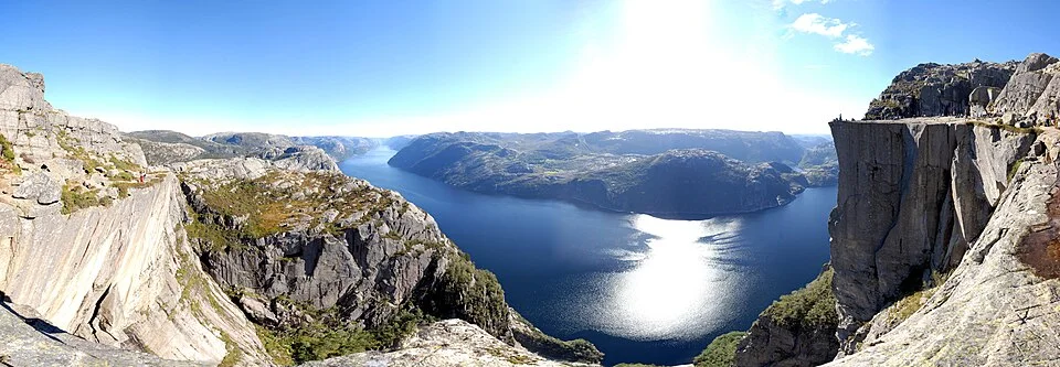
Lysefjord’s high walls and narrow water extend far inland from the island landscape near Stavanger.Photo: Carsten Steger
Forsand occupies the more open ground where Lysefjord joins Høgsfjorden. Houses and fields sit beneath the surrounding slopes, with the bridge marking the turn into the fjord. It is a useful contrast to the long, steep reaches farther inland: there is a village here, with ordinary services beside the water.
Lysefjorden Marina is in Bergevik, with the Joker grocery shop at the marina. The local destination service lists a marine service centre and fuel here. For a visit farther into the fjord, this is a useful concentration of supplies; Flørli has neither tank-water filling nor fuel.
Above the western fjord · Preikestolen
The cliff from the water and the view from the top
Preikestolen rises 604 m above Lysefjord, its flat top projecting from the northern side. From the water, the attraction is the cliff face within a much larger wall of rock. From above, the view opens along the fjord and across its opposing slopes. The two perspectives reveal different parts of the same landform.
The usual walking route starts inland at Preikestolen BaseCamp. The Preikestolen Foundation describes an 8 km return hike taking about four to five hours, with forest, wet ground, rock and stone steps along the way. Reaching the cliff by yacht and reaching the walking trail are separate arrangements; the standard trail does not begin at a quay below the cliff.
Stavanger also works as a place to leave the boat while visiting the fjord. Rødne’s departures from the city include Lysefjord cruises and combined cruise-and-hike trips. This keeps an excursion into the high landscape separate from moving the yacht away from the coastal cruising ground.
The roadless settlement · Flørli
Water power, a landing and 4,444 steps
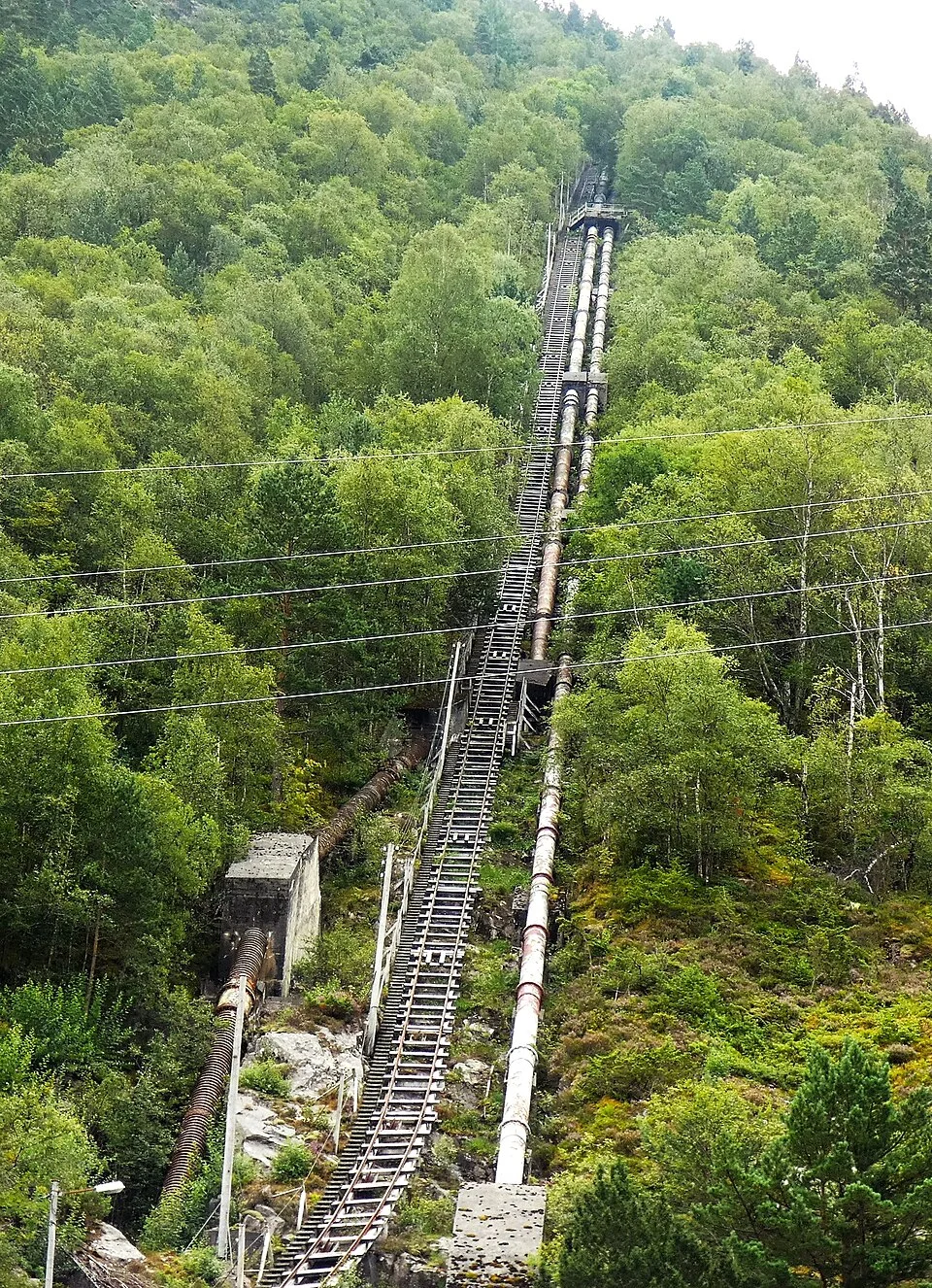
Flørli occupies a small piece of shore beneath the southern slopes of Lysefjord. Its former power station explains the settlement: water was brought down the mountainside through pipes, with a stairway beside them. The 4,444 wooden steps are now the best-known way to see the scale of that engineering.
The stairway is a sustained mountain ascent. A visit can also stay close to the water, with the historic power hall, its exhibition and the seasonal café. Flørli’s local operator describes the buildings, walking options and current café opening. The settlement is reached by boat or on foot, with no road connection.
The visitor landing brings the yacht directly to this small industrial landscape. Its position in the fjord is open enough for wind and passing ferries to be felt at the pontoons; the stillness often seen in photographs is only one of its moods.
Flørli’s stairway follows the old power-station pipes up the mountainside.Photo: Bingar1234
Near Lysebotn, Kjerag’s high rock walls dominate the southern side of the fjord. The settlement at the head is tied to hydroelectric development, with power stations inside the mountains. The road climbs away from the shore through 27 hairpin bends, a striking connection between the fjord bottom and the upland landscape.
The road also leads towards the approach to Kjerag’s walking country. As with Preikestolen, seeing the mountain from a boat is a different experience from the hike above it. Lysebotn’s small shop and café gives the settlement a shore destination at the end of the water.
The Lysefjord ferry information connects the settlements at Forsand, Flørli, Songesand and Lysebotn with the services operating through the fjord. These boats remain part of its transport system, alongside visiting yachts and sightseeing traffic.
Joining the boat · Stavanger
City transport close to the cruising ground
Stavanger is a useful meeting point for crews arriving separately. Stavanger Airport’s transport information lists the connections from Sola to the city. The railway station is at the southern side of the centre, while the guest harbours are on its northern waterfront.
A stay in Vågen or Børevigå puts food shopping, museums and restaurants within the city’s walking network. From there, the next water can be the lower islands, a branch into Lysefjord or the coast north towards Haugesund. Southbound, Tananger and Jæren bring a different horizon back into view.
Neighbouring cruising grounds
Where the coast leads
Stavanger–Bergen follows the coastal waterway through Skudeneshavn, Haugesund and the islands of Sunnhordland. Skagerrak to Stavanger explores the coast through Tananger, Jæren, Egersund and the southern outports. The Western Norway overview brings these landscapes together.
Map data and licence notices
Coastline extract from GSHHG 2.3.7 by Paul Wessel and Walter H. F. Smith: regional GeoJSON, dataset notice, LGPL and GPL. Map composition: sol.blue.