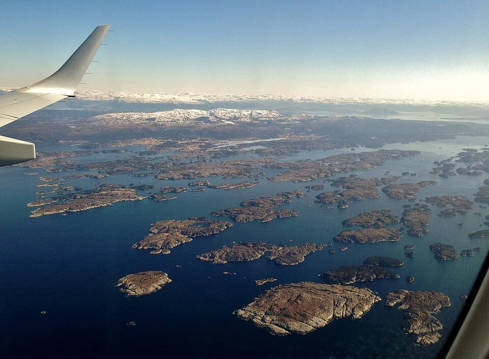
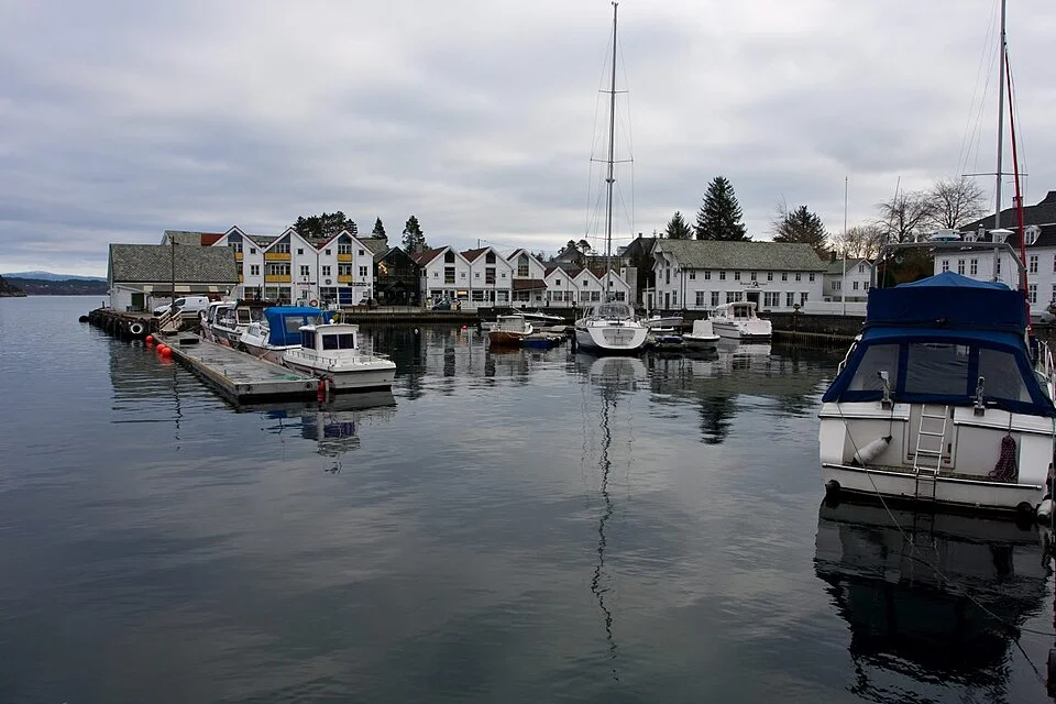
White wooden ports, royal ground beside a narrow sound, island villages and a city built around its harbour. Between Stavanger and Bergen, the coast opens into a long, inhabited waterway, with the North Sea appearing between its sheltered reaches.
Stavanger and Bergen lie roughly 86 nautical miles apart in a straight line. The coast between them takes a more intricate course: across Boknafjorden, alongside Karmøy through Karmsundet, past Haugesund and the open water of Sletta, then among the larger islands of Sunnhordland. From there, sheltered sounds lead towards Bergen while Hardangerfjorden opens a substantial branch inland.
The Norwegian word leia means the coastal passage or fairway. Here it describes a connected landscape of water: sometimes a narrow sound beside houses and quays, sometimes a wide fjord mouth with mountains beyond. Towns face the passage, ferries cross it and commercial ships use the same natural corridors.
Compared with Bohuslän’s low granite archipelago, these shores rise higher and the islands are often larger, greener and more visibly inhabited. Farms, wooded slopes and small settlements run down to deep channels. Bømlo and Austevoll still have outer islands and skerries, but the broad sounds around Stord and Tysnes give this coast a different scale.
For centuries, movement along this coast happened most easily by water. The history of leia connects royal journeys and coastal trade with fishing boats, ferries and steamships. Trading places and inns grew beside useful harbours; later, steamship calls reinforced some of those settlements as local centres.
That history remains unusually legible from a boat. A church overlooks a strategic sound at Avaldsnes. Sea houses crowd the waterfront in Skudeneshavn. Haugesund’s central quay faces the channel that helped the town grow, while Bergen’s old merchant buildings still turn towards arriving vessels. The shores explain why people settled here.
North of Stavanger and its island-and-fjord gateway, the water broadens into Boknafjorden. The lower islands around the city give way to a more open crossing towards southern Karmøy. Skudeneshavn sits near the island’s southern tip, while Karmsundet leads along its eastern side.
Boknafjorden is one of the interruptions in the coast’s shelter. Wind and sea can reach in from the west, and the feel of the passage differs from the enclosed sounds beyond it.
Karmøy makes the next choice easy to picture. Its outer shore faces the North Sea, while its eastern side forms one wall of Karmsundet. Skudeneshavn belongs to the southern entrance, with the old town folded around its harbour rather than strung along the main channel.
Southern Karmøy · An old sailing and fishing port
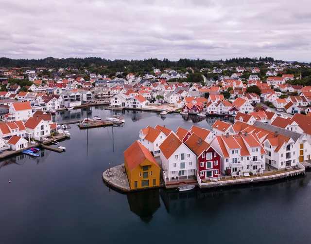
Skudeneshavn’s white houses and sea stores
The harbour brings the old town into view at close quarters: white timber façades, red roofs, narrow gaps between buildings and sea houses at the water’s edge. The streets behind them are small enough to wander without a destination, repeatedly returning to glimpses of the boats.
Much of old Skudeneshavn grew with the nineteenth-century herring fisheries and sailing trade. Herring returned to these waters in 1808; fishing, salting, shipping and commerce transformed an older harbour into a busy town. The buildings reflect both the work at the quay and the prosperity it brought ashore.
Skudeneshavn Museum makes those connections concrete. Original boats and fishing equipment sit alongside sea-house history, furnished domestic rooms, a shop, a barber’s and a dentist’s office. It gives different ages something tangible to look at, from the tools of the fisheries to the detail of everyday rooms.
Karmsundet runs between Karmøy and the mainland, gathering the coastal traffic into a narrower, more sheltered corridor. Its geography makes the importance of Avaldsnes immediately understandable. A seat of power here could watch the movement along the coast.
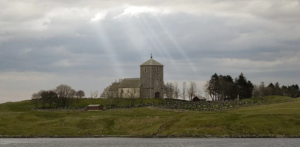
The stone church of St Olav stands above the sound. Around it, Avaldsnes and the Nordvegen History Centre explore a royal landscape whose story extends well beyond the Viking Age. Archaeological finds and exhibitions connect the site with rulers, trade and control of the waterway.
The reconstructed Viking farm on Bukkøy adds buildings and outdoor space to that story: a longhouse, boathouse and paths through the shore landscape. The church, history centre and farm make a substantial land visit, with the sound still visible as the reason for being here. Seasonal opening information is published by the site.
St Olav’s church marks the royal landscape beside Karmsundet.Photo: Henry Leirvoll
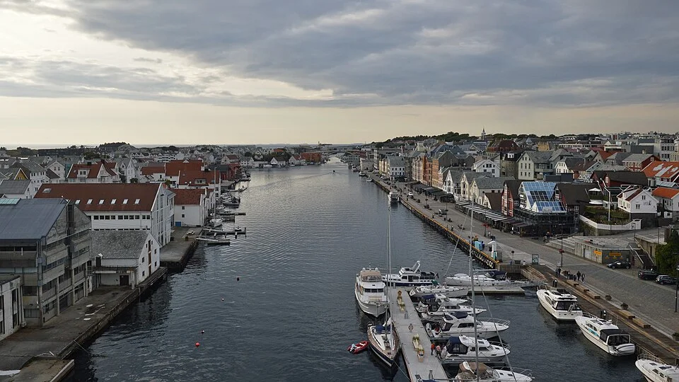
Smedasundet has buildings, quays and vessels on both sides, with the city centre close behind the eastern waterfront. Restaurants and cafés face the channel; streets rise away from it into the town. An evening here has an urban setting, quite different from Skudeneshavn’s smaller old harbour.
Haugesund’s growth followed the nineteenth-century herring fisheries, and it became a town in 1854. Shipping developed alongside fishing and trade. The modern maritime economy is still visible around the wider port, including offshore service activity; the city is a working part of the coast.
A central berth puts a walk along Indre kai, food shopping and a meal ashore within the same small area. The waterfront is also a place to watch the channel’s traffic from land, with Risøy opposite and the bridge framing the southern view.
Smedasundet runs through Haugesund’s urban waterfront.Photo: Ryan Hodnett
Beyond Haugesund, the offshore islands no longer form the same continuous screen. Sletta is the open water between the Røvær area and the skerries approaching Bømlafjorden. The North Sea can send swell directly into this reach, so the change from the enclosed channels is more than a change of scenery.
Ryvarden’s lighthouse stands on a low, rocky headland near the northern end. Its position makes it a recognisable shore landmark at the transition towards Bømlafjorden and the larger islands beyond. The land is exposed, with long sea views rather than the intimate waterfronts farther south.
Ashore, Ryvarden’s gallery and café occupy the former lighthouse buildings. The walking approach is about 2 km each way from Mølstrevåg. A memorial remembers the 16 people who died in the Sleipner fast-ferry disaster in 1999; it is a quiet part of the headland’s more recent history.
Bømlo, Stord and Tysnes · Back among the islands
Sunnhordland opens into several waterways
North of Sletta, Bømlafjorden opens between Bømlo and the mainland before reaching the southern end of Stord. From here the coast becomes a network again. Langenuen runs up Stord’s eastern side, with Tysnes beyond it; west of Stord, Bømlo and the smaller Fitjar islands create a more broken pattern of sounds.
The larger islands support towns, farms, roads and industry as well as wooded shores. A ferry crossing or a ship in the channel is part of the scene. Farther out, the horizon loosens towards the North Sea. Farther in, mountain sides and the branching Hardanger waters draw the view east.
Leirvik offers a town harbour at Stord’s southeastern corner. Fitjar looks into its own island group from the northwest, and Bekkjarvik gathers guest boats around an old trading place in Austevoll. Each gives a different shore setting to the surrounding water.
The Fitjar islands have a particularly legible shape from above: long, low ridges with narrow waterways between them. Fractures in the bedrock, enlarged by glacial erosion, helped form the parallel sounds. Nyleia, Trollosen and Hjelmosen are part of that pattern.
At water level, the same structure produces repeated changes of foreground: a rocky shoulder, a length of grassy shore, another opening into the next sound. Fitjar village sits at the edge of this island world, with the larger slopes of Stord behind it.
The Fitjar islands reveal the long lines of rock and water west of Stord.Photo: Frokor
Leirvik’s municipal guest harbour occupies the inner harbour beside the centre. Shops, restaurants and museums are close by, while the waterfront walk reaches the breakwater and Sissel Tolaas’s large sculptural gateway, Storddøra.
Langenuen: the long sound east of Stord
Langenuen gives the northward coast a strong line between larger shores. Stord lies to the west, Tysnes to the east, and the water connects Sunnhordland with the passages towards Austevoll and Bergen. The scale is broader than the small channels around Fitjar, with hills and settlements visible across the sound.
Its place in the coastal transport network explains the mix of traffic: visiting yachts share this corridor with ferries and working vessels. The small harbours belong to a coast whose everyday journeys still use the water.
Austevoll · An island trading place
Bekkjarvik gathers around its harbour
Bekkjarvik lies on Selbjørn, where harbour buildings, the old guesthouse and Bekkjarvik Torg’s shops make a compact shore centre. White façades face the boats, with low hills behind.
A meal by the harbour and a walk towards Kongsen offer different ways into the place. The higher ground opens a view across Austevoll’s islands and sea passages.
Hardangerfjorden branches away from the coast into a much larger inland landscape. Including Bømlafjorden and the long arm to Odda, the fjord system extends about 97 nautical miles. Rosendal lies well before its inner reaches, on the mainland shore northeast of Stord, where the mountains already give the water a different setting.
The village brings a harbour, shops and a walk inland to Baroniet Rosendal, the small manor completed in 1665. Its rose garden, kitchen garden and landscape park sit beneath the mountains. The house and gardens add a very different shore visit to the fishing ports and island towns of the outer coast; the estate also hosts concerts and exhibitions.
Farther into Hardanger, successive named reaches divide towards places such as Jondal, Utne, Odda, Eidfjord and Ulvik. The branching geography matters: this is a departure from the coastal waterway towards Bergen, opening a separate world of long fjord shores and mountain-backed settlements.
The southern approach · Sounds behind Sotra
The old entrance to Bergen
South of Bergen, the islands gather the approach into another sequence of connected waters. Bergensleia, the traditional southern approach, passes east of Store Sotra through Lerøyosen and Raunefjorden. Farther north, Kobbeleia runs west of Tyssøy and Bjørøy, while Vatlestraumen lies on their eastern side. Both belong to the approach towards Byfjorden and the city.
The outer entrance near Marstein looks towards the sea. Inside, island shores and the mainland increasingly enclose the view. The city is reached through these working waterways, where the long coastal passage becomes an urban harbour approach.
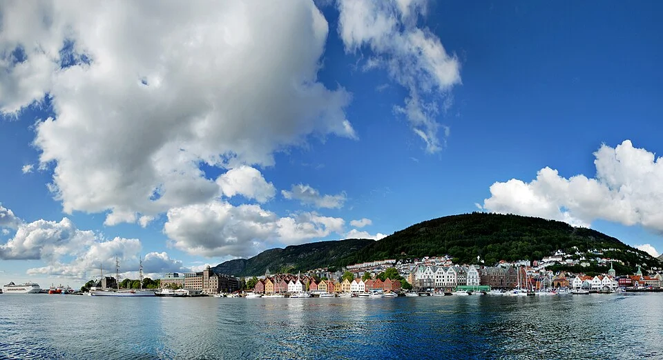
Byfjorden then gives the city its larger setting. Bergen’s hills rise behind the waterfront, and Vågen cuts into the centre. Arriving from the water makes the relationship between the old quays, the town and its trading routes particularly clear.
Vågen and Bryggen · The city around the boat
Bergen’s harbour is the front door
Vågen reaches into central Bergen with quays on both sides and the old merchant quarter of Bryggen along its eastern shore. The timber façades form the familiar view from the water; walking between them reveals narrow passages, deep building plots and the scale of a trading settlement organised around the harbour.
Bryggen’s Hanseatic history connects Bergen with the wider northern European trade network. The present wooden buildings largely followed the fire of 1702, retaining the older pattern of merchant properties. That distinction is part of their interest: a commercial layout repeatedly rebuilt in the same close relationship with the quay.
The centre is compact enough for the waterfront, small streets, cafés and food shopping to belong to one walk. From the harbour, the slope of the city is always visible. The Fløibanen funicular climbs to Fløyen in about six minutes, opening a view back across the roofs, harbour and islands. Walking trails and a playground extend the visit beyond the viewpoint.
Bergen changes the scale of a stay ashore. There are museums and long afternoons in town as well as an evening meal near the boat. Yet the coastal geography remains present: from above, the sounds and islands of the approach can be seen as part of the same landscape as the city below.