Cruising grounds · Irish Sea

The Irish Sea,
shore to shore.

Welsh castle towns, Dublin Bay’s harbour walls, Manx fishing quays and the islands of Strangford face a shared sea.

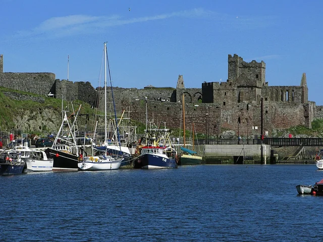
Fishing boats beside a quay in Peel, with the castle’s stone walls and ruined towers behind.
Peel Harbour and castle · August 2008.
Photo: Phil Sangwell / Philandthehound

Follow one coast, or cross open water to another. Between them, the Isle of Man opens choices towards several shores. A local sail through a sheltered waterway and a passage across the Irish Sea offer different ways to explore the same region.

England, Wales and Ireland

Find your bearings

Across as well as along.

Wales lies to the east and Ireland to the west, with the Isle of Man between. Pembrokeshire opens towards the Celtic Sea in the south; Belfast Lough and Strangford lead towards the North Channel in the north. The passages between these shores give the region its scale.

Irish Sea: shores and crossingsIreland lies west of Wales, with the Isle of Man between them. The numbered destinations link to Milford Haven, North Wales, Dublin Bay, the Isle of Man, Belfast Lough, Strangford Lough, Rathlin and Campbeltown. Belfast Lough and Strangford are separated by the Ards Peninsula.Irish SeaShore to shore1Milford HavenPembrokeshire2Conwy3Dún Laoghaire4PeelIsle of Man5BangorBelfast Lough6StrangfordLough7Rathlin8CampbeltownIRELANDWALESIrish SeaSCOTLAND40 nautical milesNNatural Earth · sol.blue Irish Sea: shores and crossingsIreland lies west of Wales, with the Isle of Man between them. The numbered destinations link to Milford Haven, North Wales, Dublin Bay, the Isle of Man, Belfast Lough, Strangford Lough, Rathlin and Campbeltown. Belfast Lough and Strangford are separated by the Ards Peninsula.The Irish Sea, shore to shoreWALES · IRELAND · ISLE OF MAN · NORTHERN LOUGHS1Milford Haven / Pembrokeshire2Conwy3Dún Laoghaire4Peel · Isle of Man5Bangor · Belfast Lough6Strangford Lough7Rathlin8CampbeltownTowards the ClydeIRELANDWALESSCOTLANDI R I S H S E AAngleseyMenai StraitGreystonesArklow · possible extensionDouglas · east coastMilford MarinaDaleNeyland · Milford · DaleNORTHERN IRELAND40 nautical milesNExplore the shores · Rathlin and Campbeltown connect with ScotlandNatural Earth 1:10m land v5.1.1 · September 2026HowthWicklow
Coastline: Natural Earth, public domain. Cartography: sol.blue, CC0.
  1. Milford Haven / Pembrokeshire

    A sheltered working waterway, with the outer coast beyond Dale.

  2. North Wales and Anglesey

    Conwy’s castle, the Menai Strait and the mountains across the water.

  3. Dublin Bay and Wicklow

    Dún Laoghaire, Howth and a small harbour with a major offshore race.

  4. Isle of Man

    Peel, Douglas and smaller harbours around a central island.

  5. Belfast Lough

    Bangor’s waterfront and Belfast’s docks, ships and industrial history.

  6. Strangford Lough

    A tidal entrance opens into broad water scattered with islands.

  7. Rathlin

    An island at the northern opening of the sea.

  8. Campbeltown

    Kintyre’s east coast and the connection towards the Clyde.

A sense of the distances

Neyland–Dún Laoghaire is about 105 nautical miles in a straight line; Conwy–Dún Laoghaire about 82, Dún Laoghaire–Peel 76 and Bangor–Peel 43. These are geographical minimum distances, not sailing distances or passage times. Approaches, tides, land and weather change the actual journey.

Inside Milford Haven, Neyland’s operator gives about 4 nautical miles to Milford and 8 to Dale, without specifying the tracks. These local connections are a different scale from the crossings between Wales, Ireland and the Isle of Man.

Neyland’s local distances

Explore the shores

Five areas, connected by water.

The harbours face the sea because it has long carried people, goods and stories between them. Their castles, ferry quays, sailing clubs and working docks give each shore its own character.

Milford Haven · Pembrokeshire

A natural haven, still at work.
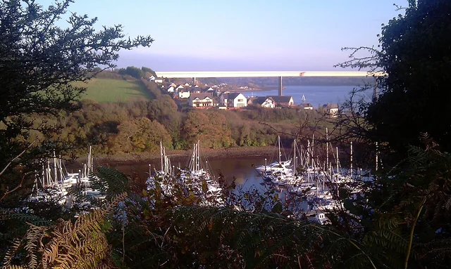
Masts in Neyland Marina framed by autumn trees, with Barnlake Point and the bridge over Milford Haven behind.
Neyland Marina and Barnlake Point · November 2011.
Photo: Agathoclea

Milford Haven begins with a generous piece of geography: a river valley flooded by the sea. The deep, branching waterway has sheltered Viking ships, whalers, fishing fleets and naval vessels. Today tankers, ferries and yachts share it. The terminals and commercial quays belong to the place as surely as the wooded creeks and village waterfronts.

Neyland, Milford and Dale offer different shores within that same waterway. Neyland puts the Brunel Trail close to the marina; Milford’s docks bring shops, restaurants and the harbour’s history together. Near the mouth, Dale has a village waterfront and a pebble-and-sand beach. Moving between them brings the working port and its quieter corners into the same view.

The story of Milford’s waterway

The port authority’s visitor buoys have limits of about 12.2 metres and 10 tonnes, with separate day-use and overnight categories. These limits apply to those buoys, rather than to private marina berths. At Dale, the choice of mooring also determines the dinghy trip ashore.

Milford Haven visitor arrangements

Beyond the mouth: Pembrokeshire’s outer coast

Outside the Haven, the coast opens towards the Celtic Sea. Skomer and the Marloes Peninsula bring cliffs, seabirds and protected marine habitats into the picture. This is a change from the inner waterway to exposed coastal sailing. Around Skomer, anchoring is restricted to South Haven and specified parts of North Haven; a yacht anchorage and permission to land on the island are separate matters.

Skomer Marine Conservation Zone
North Wales · Anglesey · Menai

Castles, bridges and moving water.

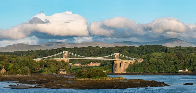
Menai Suspension Bridge above wooded shores and rocky islets, with mountains beyond.
Menai Suspension Bridge and the mountains beyond · August 2019.
Photo: Julian Herzog

Conwy’s castle stands above the river approach, with the walled town gathered behind it. From the water, the relationship between fortress, harbour and town is immediate. The castle visit and a walk along the quay belong together; the mountains inland give this corner of the coast a scale beyond the marina.

Anglesey and the inside water

Between Anglesey and the mainland, the Menai Strait changes the view: wooded shores, rocky islets, the suspension bridge and the mountains of Eryri across the water. Beaumaris faces the eastern end; Caernarfon lies towards the southwest. The Swellies, between Menai Suspension Bridge and Britannia Bridge, are the concentrated tidal heart of this passage. Shelter from waves here comes with fast-moving water.

Menai’s landscape and wildlife

The approach to the castle is steep and stepped. On 18 September 2026, parts of the town wall were closed; Cadw’s hoped-for reopening by Easter 2027 was not confirmed.

Conwy Castle and current access notices

Beaumaris brings another castle and a waterfront looking across the Strait. Anglesey’s coast and the mainland towns make this a cruising area with life on both shores. Heading outside the island opens a different, more exposed relationship with the Irish Sea.

Dublin Bay · Wicklow

City harbours and a sailing coast.

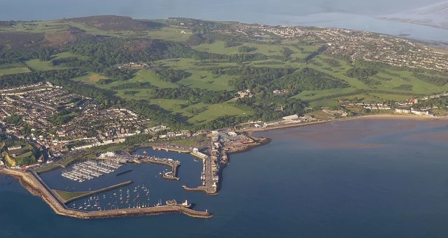
Aerial view of Howth’s enclosed harbour, marina, fishing quays and green peninsula.
Howth’s harbour and peninsula from the air · June 2015.
Photo: Robert Linsdell from St. Andrews, Canada

Dublin Bay offers two quite different arrivals. Dún Laoghaire occupies the southern shore behind enormous harbour walls; Howth has a working harbour beside a green peninsula to the north. Both connect to Dublin by DART, so the city and the coast can be explored from the same berth.

Howth: fishing harbour and headland

Howth’s fishing quays, seafood places and walks around the headland give it a harbour-village character close to the capital.

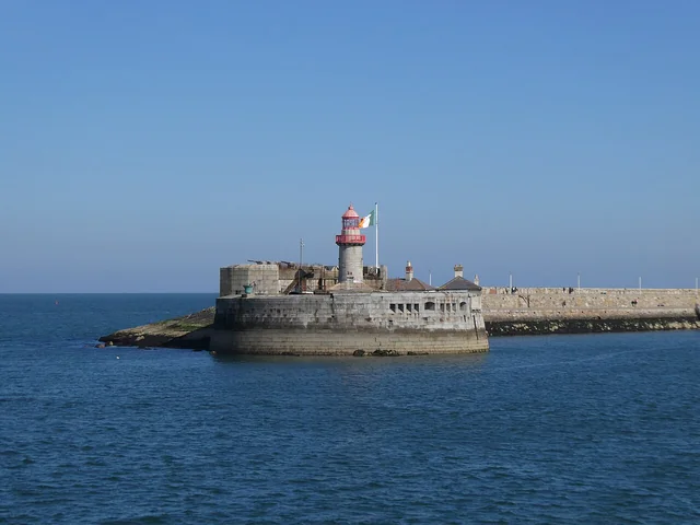
A red-topped lighthouse stands at the end of Dún Laoghaire’s stone East Pier, across the blue harbour water.
East Pier, Dún Laoghaire · May 2025.
Photo: Gareth James

Dún Laoghaire: a harbour built for shelter

Construction of Dún Laoghaire’s harbour of refuge began in 1817. Its long stone arms explain the scale of the place before you step ashore. Walking East Pier turns that engineering into a view across the bay; the maritime museum, cafés and Sunday market bring the town closer.

Explore Dún Laoghaire ashore

Wicklow: a small harbour with a long reach

Farther south, Wicklow’s modest working harbour has an offshore reputation out of proportion to its size. Wicklow Sailing Club launched the Round Ireland Yacht Race in 1980; the approximately 704-nautical-mile race still starts and finishes here. The club’s links across the Irish Sea, including its connection with Porthmadog in Wales, give the idea of a shared sailing sea a human scale.

The Round Ireland story
Greystones and the coast south

Greystones offers another marina and town stop south of Dublin Bay. The Bray–Greystones cliff path was closed as a through route when checked on 18 September 2026; use the council’s latest notice when choosing a walk. Arklow lies farther south; its visitor description dates from 2021, so current harbour arrangements need confirmation.

Cliff-walk notice Arklow visitor description (2021)

Isle of Man

An island with several shores within reach.

From the Isle of Man, the surrounding shores become choices in several directions: Ireland to the west, Wales to the southeast, the northern loughs and Scotland beyond. The island also has a maritime world of its own. A self-governing Crown Dependency with its own parliament, it carries a distinct Manx identity shaped by Celtic, Norse and seafaring history.

Peel: castle, fishing quays and Manx stories

Peel’s castle and fishing harbour sit together on the west coast. The House of Manannan follows the island’s Celtic and Viking history into the working port of the nineteenth century, with a seagoing replica longship and stories of fishing, trade and island ferries. A walk around the castle and a visit to the museum make the harbour’s wider connections tangible. Peel’s kippers, split and smoked herring, carry the fishing tradition onto the table; Devereau’s lists a factory shop on Mill Road.

Devereau’s Manx kippers House of Manannan

Douglas and the smaller harbours

Douglas faces east, with the capital’s waterfront and ferry traffic. Around the southern end, Port St Mary has a different scale: fishing boats, pleasure craft and diving vessels share a small harbour. Port Erin, Castletown and Ramsey broaden the island’s geography further; their individual harbour arrangements make each a separate choice.

Belfast Lough · Strangford

A working city, an island-filled lough.

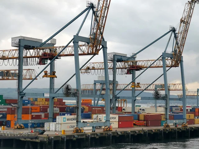
Large quayside cranes above stacked containers at Belfast’s working port.
Container cranes at Belfast’s Victoria Terminal 3 · July 2019.
Photo: Phil Champion

Belfast Lough: from Bangor to the working city

Bangor offers a marina and town waterfront near the mouth of Belfast Lough, with rail access to Belfast. Around Eisenhower Pier, the waterfront carries a wartime story as well as everyday harbour life: the pier recalls Eisenhower’s 1944 visit to troops preparing for Normandy. Black guillemots nesting here are locally known as “Bangor Penguins”.

Farther into the lough, Belfast’s docks explain how a port helped make a city. Straightened channels and reclaimed land created room for larger ships, quays and shipbuilding. The waterfront still holds cranes, ferries and cargo alongside its museums and newer buildings. Along the Maritime Mile, the slipways, SS Nomadic and Thompson Dock make the industrial scale visible; Titanic is one part of that larger story.

Explore Belfast’s Maritime Mile
Strangford Lough and the NarrowsA closer view of Strangford Lough. The Ards Peninsula forms its eastern shore. Strangford and Portaferry face one another at the narrow southern entrance; the lough broadens north towards Newtownards. Quoile and Castle Ward lie on the southwest side.Inside StrangfordStrangfordPortaferryQuoileCastle WardNewtownardsStrangfordLoughArds PeninsulaThe NarrowsIrish Sea5 nautical milesN
The Narrows connect the open sea with the much wider lough. Coastline: GSHHG 2.3.7.
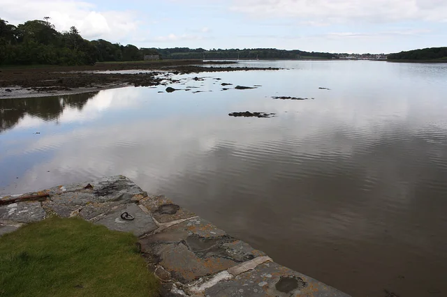
The stone edge of Castle Ward’s quay beside still water, with wooded shores, exposed rocks and distant boats on Strangford Lough.
Strangford Lough from Castle Ward Quay · June 2011.
Photo: Ardfern

Strangford: through the Narrows, into another scale

Strangford lies around the Ards Peninsula from Belfast Lough. Its entrance gives little hint of the water inside: a narrow tidal channel opens into a broad lough scattered with islands, shallows and wooded shores. The change from open sea to this enclosed landscape is one of the region’s strongest contrasts.

Sailing clubs, village quays and birdlife give the interior its character. Strangford and Portaferry face one another across the entrance, joined by the ferry. Farther inside, the islands and tidal flats make the shoreline change with the water level. Castle Ward’s 4 km loughside walk follows woodland and shore, with some short, steep sections; the estate visit has its own admission and land-access arrangements.

The roughly four-nautical-mile Narrows can carry currents up to 8 knots. That concentrated entrance governs access to the lough; shelter inside does not remove the need to time the passage through it. The local landscape authority explains the channel and the protected habitats beyond.

The lough and its tidal entrance Castle Ward loughside walk

The rhythm of the sea

Follow the coast, or cross to another.

A sail within Milford Haven, a passage through Menai and a crossing from Wales to Ireland have very different scales. The appeal is the change between them: enclosed water and close shores, then open sea and a landfall with another language, history and harbour culture. Ferries, fishing boats and trading ships still use these connections alongside yachts.

The Isle of Man makes several directions possible without prescribing the next shore. Weather and the tidal access at the destination shape which passage is attractive: a short distance on the map can still mean steep seas, while a suitable window opens an entirely different coast. Time in a harbour and time at sea both belong to the cruise.

Getting there and looking after the boat

Arrivals and working bases.

Joining the boat

Dún Laoghaire, Howth and Bangor combine sailing with rail access to a city. Dún Laoghaire also has a direct airport coach; Bangor connects to Belfast City Airport through the city’s bus and rail network.

Airport and station connections

Aircoach 702 connects Dublin Airport with Dún Laoghaire; the timetable reviewed is valid through 23 December 2026. Bus 600 from Belfast City Airport runs to Grand Central, with trains onward to Bangor. The marina is about 800 metres from Bangor station.

Aircoach 702 Getting to Bangor Marina

Lifting and boat work

Milford and Conwy provide named options for work ashore. Milford lists a 20-tonne hoist and hardstanding; Conwy a 30-tonne hoist, cradles and rigging services. The yard needs the boat’s dimensions and keel arrangement to agree a lift and storage space.

Milford boatyard Conwy boatyard

Where the sea opens next.

At the northern opening, the North Channel leads towards Scotland and the Clyde. From Milford Haven, the water opens towards Ireland and south into the Celtic Sea and Southwest England. These are the seams between cruising grounds, with another set of shores beyond each one.

Rathlin, at the northern opening

Rathlin offers a separate island landfall near Ballycastle. Its ferry also makes an island visit possible from the mainland. The West Light Seabird Centre is about 7.2 km from Church Bay and involves many steps; its seasonal opening matters when planning that particular outing.

Rathlin’s West Light Seabird Centre has ended its 2026 season; future opening times, island transport and any yacht berth remain to be established. The centre is about 7.2 km from Church Bay, with many steps.

Rathlin’s season information

Campbeltown and the Clyde

Campbeltown lies on Kintyre’s east coast, beyond the northern opening of the Irish Sea. It connects this guide with the Clyde, Arran and Kintyre cruising ground. Arrival by land needs a different plan from a yacht passage.

CalMac’s notice confirms no Ardrossan–Campbeltown service in summer 2026. Older general ferry descriptions from marinas and the council are not a basis for planning arrival.

CalMac’s Campbeltown notice

A little scenery in motion

Harbours and days aboard.

Two crews’ glimpses of local places, with time both ashore and afloat.

Sources and photo credits Sources checked 18–22 September 2026

Harbours and local information

Neyland · basins, connections and distances Milford · entrance lock Greystones · marina Peel · detailed harbour information Douglas · separate access arrangements Rathlin · ferry timetable Belfast Harbour history Dún Laoghaire: harbour construction Wicklow Sailing Club history

Photographs and maps

Photograph dates and credits appear beside each image. The linked source records retain the creator and licence for each photograph and the coastline data.

Photo and map sources (JSON)

Strangford coastline: Paul Wessel and Walter H. F. Smith, GSHHG 2.3.7. Geographic extract (GeoJSON) · dataset notice · LGPL 3 · GPL 3.