The Southern Inner Hebrides · Scotland

Islay, Jura
and Colonsay

Atlantic islands.
Powerful tidal sounds.

Here the Scottish west coast opens into a more exposed island world. There are fewer marinas than in the Clyde, the Atlantic reaches the western shores, and strong tides shape passages through the sounds. Sailing can be exhilarating and sometimes demanding: sheltered water beneath Jura’s mountains lies close to empty coasts facing the ocean.

Islay brings distilleries, villages and the maritime world of the Lords of the Isles. Jura brings the Paps and remote sea lochs. Colonsay brings white beaches, community moorings and a walk to another island when the tide allows.

Explore Scotland
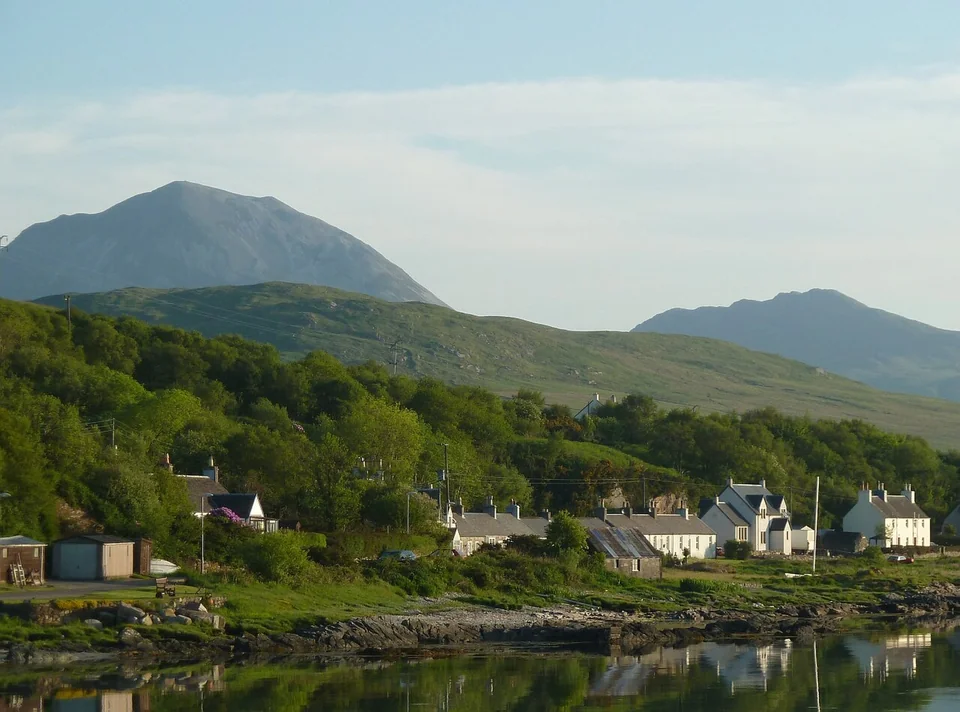
Craighouse's houses reflected in still water, with wooded slopes and the Paps of Jura behind.
Craighouse and the Paps of Jura, photographed in 2012.
Photo: Rob Farrow

Reading the islands

An inside coast.
An Atlantic coast.

Jura’s long eastern shore faces the relatively sheltered Sound of Jura and the mainland. Across the island, the western coast opens to the Atlantic. Islay has the same contrast; Colonsay sits farther out, northwest of the two larger islands and south of Mull.

Islay, Jura and Colonsay geographic locator North up. Islay lies southwest of Jura; Colonsay lies northwest, towards Mull. The Sound of Islay separates Islay and Jura; the Sound of Jura lies between Jura and the mainland. Loch Tarbert opens into western Jura. Corryvreckan separates northern Jura and Scarba. Linked markers lead to Port Ellen, Port Askaig, Craighouse, Colonsay and Ardfern. ISLANDS & SOUNDS Islay Jura Colonsay Mull Kintyre 1 · Port Ellen 2 · Port Askaig 3 · Craighouse 4 · Queen’s Bay & Scalasaig 5 · Ardfern ≈ 5.4 nautical miles N Natural Earth · © OpenStreetMap contributors Atlantic Sound of Islay Sound of Jura Loch Tarbert Corryvreckan Islay, Jura and Colonsay geographic locator North up. Islay lies southwest of Jura; Colonsay lies northwest, towards Mull. The Sound of Islay separates Islay and Jura; the Sound of Jura lies between Jura and the mainland. Loch Tarbert opens into western Jura. Corryvreckan separates northern Jura and Scarba. Linked markers lead to Port Ellen, Port Askaig, Craighouse, Colonsay and Ardfern. ISLANDS & SOUNDS Islay Jura Colonsay Mull Kintyre 1 · Port Ellen 2 · Port Askaig 3 · Craighouse 4a · Scalasaig 4b · Queen’s Bay 5 · Ardfern ≈ 5.4 nautical miles N Natural Earth · © OpenStreetMap contributors Atlantic Sound of Islay Sound of Jura Loch Tarbert Corryvreckan
Map credits and dataNatural Earth · public domain© OpenStreetMap contributorsDownload map data · ODbLSophie map design · CC BY 4.0

Places on the map

  1. 1
    Port Ellen · IslayVillage marina and Islay’s south-coast distilleries.
  2. 2
    Port Askaig · IslayFerry port on the Sound of Islay, facing Jura.
  3. 3
    Craighouse · JuraMoorings below the Paps, with the village ashore.
  4. 4
    Queen's Bay / Scalasaig · ColonsayCommunity moorings south of the ferry village.
  5. 5
    Ardfern · MainlandMainland marina, boatyard and storage on Loch Craignish.
  • Marina or visitor moorings
  • Ferry harbour
  • Mainland boatyard

From Crinan: the canal’s western entrance opens onto the mainland side of the Sound of Jura, with Jura’s mountain ridge across the water.

From Kintyre and Gigha: southern Islay and Port Ellen lie to the west; the Sound of Islay opens a passage between Islay and Jura towards Colonsay.

Looking north: beyond Colonsay are Mull and the Firth of Lorn. The eastern side of Jura leads towards the intricate waters around Luing and the mainland.

The water connects the islands

Through the sounds.

The Sound of Islay is the narrow passage between the two great islands: Islay’s shore on one side, Jura and the Paps on the other. A fair stream can carry a yacht through at a striking pace. The opposing stream can make the same passage slow or impractical; wind against that moving water can make it rough. Departure time here belongs to the tide as much as to the distance.

The broader Sound of Jura offers a more enclosed setting along Jura’s eastern coast. Shelter from Atlantic swell is part of its appeal, although the tidal passages at its northern end have their own character. Across Jura’s western shore and out towards Colonsay, ocean swell and exposure become much more prominent.

Marinas are only one way to stay. Port Ellen offers a village marina; at Craighouse, visitor moorings put the village a dinghy ride away. Colonsay’s community moorings sit in a quiet bay, while Loch Tarbert draws yachts into an almost uninhabited landscape. These different arrivals are part of the character of the islands.

For the detail of passages and anchorages, the Clyde Cruising Club’s Kintyre to Ardnamurchan sailing directions cover this coast. Sam Llewellyn’s account of sailing north through the islands gives a vivid sense of their tidal rhythm.

Islay

Distilleries by the sea.
An island beyond whisky.

Islay has the most varied shore life of the three islands: working villages, distillery courtyards, long Atlantic beaches and a medieval centre of sea power. Its southern coast offers a sociable arrival; the west looks straight into the ocean.

Port Ellen and the distillery coast

Whitewashed houses curve around Port Ellen’s bay, with village shops close to the marina. East along the shore, Laphroaig, Lagavulin and Ardbeg face the water. Their warehouses and old landing places make whisky part of the coastal landscape, even for visitors who never book a tasting.

The Three Distilleries Path runs about 6 km one way from Port Ellen to Ardbeg, largely away from the road. Walking or cycling connects the shore, the distilleries and a meal at Ardbeg; tours need booking, and dining follows the season.
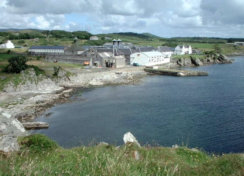
Ardbeg’s distillery buildings and lettered warehouse beside a rocky bay and stone pier.
Ardbeg across the bay, Islay, photographed in 2001.
Photo: James Gray
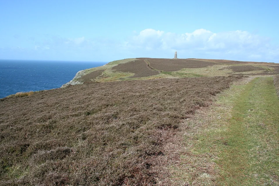
A grassy path across open coastal ground towards the American Monument, with the sea to the left.
The Oa on Islay, looking towards the American Monument.
Photo: MSeses

Western and southern Islay

Where the Atlantic comes ashore.

At Machir Bay, a long sweep of sand meets Atlantic surf. On the Oa peninsula, the coast rises into cliffs and open grassland, with seabirds below and a broad sea horizon beyond the American Monument. These are a very different Islay from the distillery shore.

The Oa’s 2.5 km circular walk passes the monument and cliff tops. The reserve is about 10 km by road from Port Ellen, with no café, toilets or shelter: transport out and back makes the difference between a village walk and this more remote outing.

The Oa reserve and walking trail

Finlaggan · Kildalton · Port Charlotte

The sea was the connection.

Finlaggan lies inland, on small islands in a loch, but its story belongs to the sea. This was a seat of the Lords of the Isles, whose power reached across the Hebrides and mainland Argyll. Galleys linked territories that a modern road map makes look separate. Islay, Jura, Mull and Kintyre were parts of a connected maritime world.

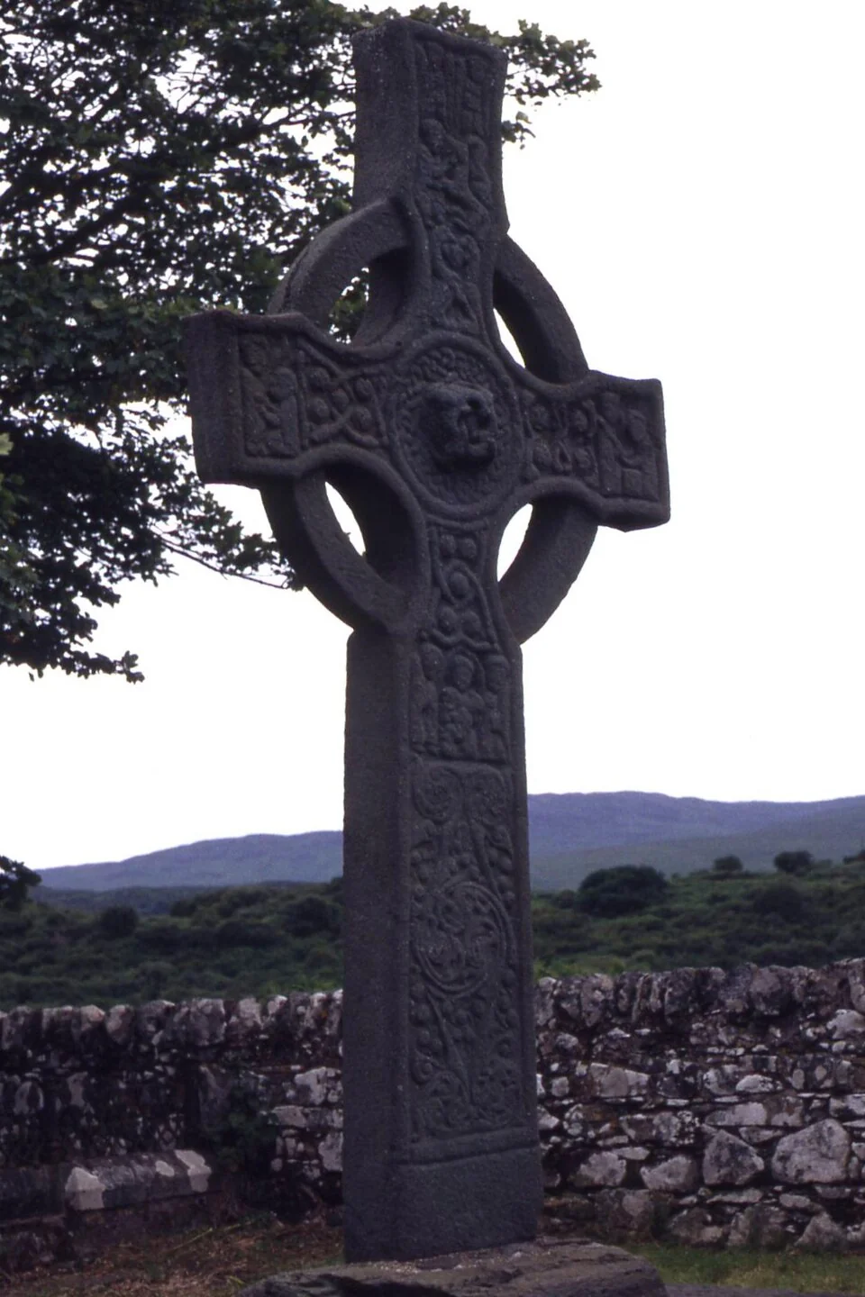
The ruins at Finlaggan make that world tangible. At Kildalton, the eighth-century carved cross still stands on its original site, farther along the road beyond Ardbeg. On Loch Indaal, the Museum of Islay Life in Port Charlotte brings the story closer to everyday island life through objects and photographs.

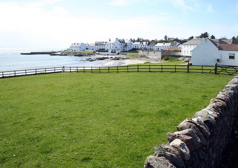
White houses along the shore at Port Charlotte, behind a green field and a stone wall.
Port Charlotte on Islay, beside Loch Indaal.
Photo: MSeses
The complete carved stone cross at Kildalton, with old stone walls behind.
Kildalton Cross on Islay, photographed in 1992.
Photo: Colin Park

Port Askaig, facing the sound

Port Askaig looks directly across the Sound of Islay to Jura. Ferries, moving water and the short crossing to Feolin give it a different role from Port Ellen: this is Islay’s hinge between islands and mainland, rather than a marina village.

The Feolin ferry connects to Jura’s road, with Craighouse farther along the coast. Visiting yachts should use the council’s Port Askaig pier information for harbour arrangements.

Jura

The Paps, a village
and a wild western shore.

Jura’s mountain ridge dominates the view long before arrival. Most of its small population lives along the eastern side; beyond the ridge are deer, open moorland and long stretches of coast with scarcely a building. Craighouse and Loch Tarbert reveal two very different sides of the same island.

Craighouse beneath the Paps

In Small Isles Bay, the village, distillery and mountains form a single scene. From a visitor mooring, a dinghy brings you to a waterfront with the shop, Jura Hotel and distillery close together. A walk along the Corran Path keeps the bay in view; the Paps give the whole place its scale.

This is one of the principal cruising stops in the group, with enough village life to make coming ashore part of the pleasure. The Jura Hotel looks over the bay, and the surrounding hills begin almost behind the houses.

Western Jura · Loch Tarbert

A sea loch that draws you into the island.

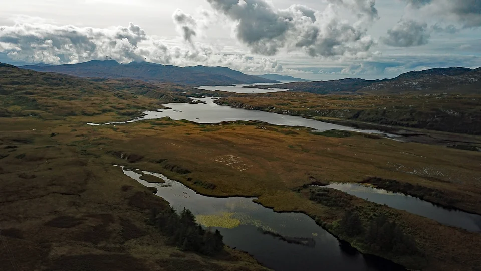
An aerial view along Loch Tarbert’s connected pools, surrounded by open hills with the sea beyond.
Loch Tarbert on western Jura, viewed from above its inner waters.
Photo: Gunther Tschuch

Loch Tarbert cuts deep into Jura from the Atlantic side. The open outer loch gives way to narrow connections and increasingly enclosed pools; farther in, the sea can seem to disappear behind the land. Raised beaches stand above today’s shore, and the hills carry almost no trace of settlement.

For a yacht, the attraction is the natural anchorage and the landscape around it. There is no village waiting at the head of a pontoon: a landing leads to shingle, moor and a remarkably quiet interior. The contrast with Craighouse is part of what makes Jura so rewarding.

The outer loch is exposed to the west; reaching the inner anchorages involves tidal narrows and close pilotage. Current charts and the area’s sailing directions belong with that choice. This sailor’s account of Loch Tarbert conveys the setting.

Orwell’s remote Jura

Near the island’s northern end, George Orwell lived at Barnhill while completing Nineteen Eighty-Four. The house’s distance from Craighouse and its exposed setting belong to the story: one of the twentieth century’s best-known novels took shape on this sparsely inhabited shore.

Corryvreckan, the northern boundary

Between Jura and Scarba, the Gulf of Corryvreckan concentrates the region’s tidal drama into one famous name. Powerful streams, overfalls and the whirlpool have made it a place of stories as well as formidable water.

Continuing north does not require a transit of Corryvreckan. To experience it from a locally operated boat, Jura Boat Tours runs trips from Craighouse and Port Askaig, with departures shaped by the tides.

Colonsay

A small island
worth seeking out.

Colonsay sits farther into the Atlantic, with a small community, low green hills and great sweeps of sand. The island itself is the reason to come. Its modest shore facilities and exposed position make the choice of weather more consequential than at a mainland marina.

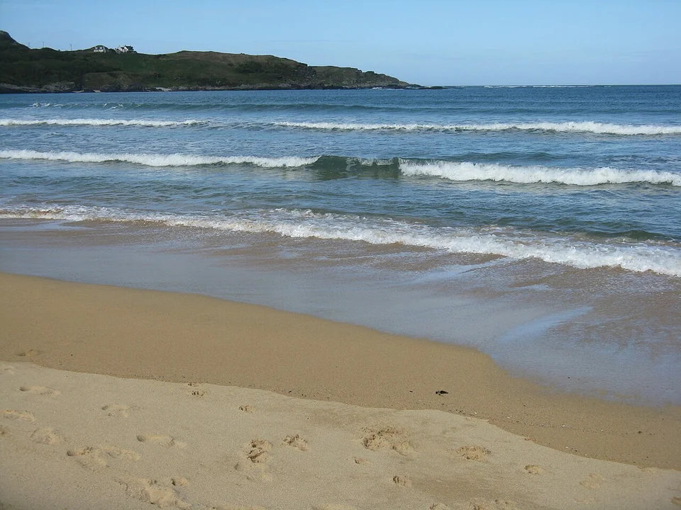
Small waves breaking across the sand in Kiloran Bay, with a low headland behind.
Kiloran Bay, on Colonsay’s Atlantic coast.
Photo: M J Richardson

Arriving in Queen’s Bay

On the east coast, south of Scalasaig, the community’s visitor moorings lie in Queen’s Bay, also called Loch Staosnaig. The arrival is simple in character: a buoy in a bay, a dinghy landing, then a walk towards the village. There are no facilities at the moorings; the path towards Scalasaig is rough and unmarked.

Across the island to Kiloran

Scalasaig gathers the ferry arrival, shop and places to eat into a small village. Beyond it, walking and cycling give access to a much wider island: quiet roads, low hills and the broad beach at Kiloran Bay on the northwest coast.

Kiloran deserves time for the beach itself: pale sand between headlands, Atlantic surf and a view that reaches well beyond the bay. Hire bikes can be delivered by agreement. Back in Scalasaig, the Pantry follows seasonal opening hours.

The Strand · Oronsay

When the tide opens a path to another island.

South of Colonsay, the Strand separates the island from Oronsay. At sufficiently low tides, the sands become a crossing on foot to a medieval priory. Here the tide determines when people walk between islands as well as when boats sail between them.

The fourteenth-century priory and its carved stones connect Oronsay to the same maritime world as Finlaggan. Local tradition takes the story farther back: Columba is said to have stopped here from Ireland, then continued to Iona because he could still see his homeland.

The crossing is possible only on suitable low tides, not every day. The island post office gives local advice on the day’s crossing; Oronsay is also a working farm and an important wildlife site. The community’s Oronsay guide explains access and wildlife considerations.

Farther north: Mull and the Inner Hebrides

Connections ashore

Getting here.

Colonsay by ferry

Scalasaig is Colonsay’s ferry arrival. CalMac’s Colonsay timetable covers Oban and the connections with Port Askaig and Kennacraig; the pattern varies by day and season.

Ardfern on the mainland

Photographs and map credits

Photographers, dates and licences are listed beside each photograph. The Kildalton view dates from 1992.

Photo and map sources