Scotland · Cruising grounds

Mull and the Sound.
From the old sea-road to the Atlantic.

On Mull’s eastern side, a yacht follows one of western Scotland’s old sea-roads through the relatively sheltered Sound. Hills on both shores contain the Sound, where ferries, fishing boats and visiting yachts pass castles and harbour towns. Round the island’s northern coast and the mainland falls away: the west opens towards Atlantic swell, volcanic cliffs and small offshore islands.

The pleasure of sailing here lies in that change. The Sound’s harbours draw you into communities whose lives still depend on the water. Beyond them, dark columns rise from the sea at Fingal’s Cave, and summer brings seabirds to the grassy islands offshore.

Explore Mull on the map ↓
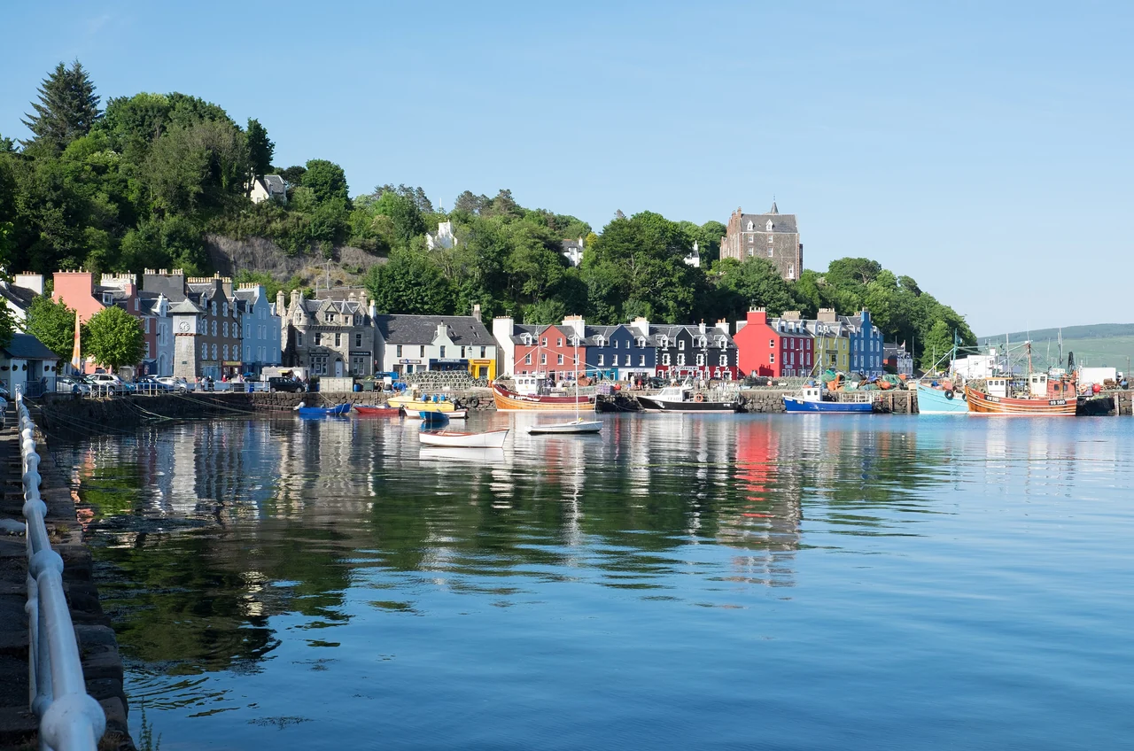
Colourful houses and boats reflected in the water along Tobermory’s waterfront.
Tobermory’s colourful waterfront · 18 June 2016.
Photo: DeFacto

One island, two coastlines

The Sound inside.
The Atlantic beyond.

The Sound runs northwest between Mull and the mainland peninsula of Morvern. Its southern entrance connects with the Firth of Lorn and Oban; Tobermory lies near the northern end. Around northern Mull, the western coast turns towards Loch na Keal, Ulva and the offshore islands. Iona is farther south, off Mull’s southwestern tip.

Mull and the Sound of MullThe Sound of Mull runs between Mull and Morvern, from the Oban approaches towards Tobermory. Beyond northern Mull, the Atlantic coast opens towards Ulva, Staffa and the Treshnish Isles. Iona lies off the southwestern tip.Mull and the Sound of MullFrom the Sound to the Atlantic1 TobermoryAros Park near town2 Lochaline3 Calgary4 Ulva Ferry5 Lunga5 Staffa6 Iona7 ObanMullSound of Mull● Sound of Mull harbours○ Western coast and islands■ Oban connections≈ 5.4 nautical milesN© OpenStreetMap contributorsMull and the Sound of MullThe Sound of Mull runs between Mull and Morvern, from the Oban approaches towards Tobermory. Beyond northern Mull, the Atlantic coast opens towards Ulva, Staffa and the Treshnish Isles. Iona lies off the southwestern tip.Mull and the Sound of MullFrom the Sound to the Atlantic1 Tobermory / Aros Park2 Lochaline3 Calgary4 Ulva FerryUlva5 Lunga5 Staffa6 IonaFionnphortCraignure7 ObanMullSound of Mull● Sound of Mull harbours○ Western coast and islands■ Oban connections≈ 5.4 nautical milesN© OpenStreetMap contributors
© OpenStreetMap contributors · Map data · ODbL · Sophie cartography · CC BY 4.0

Entering from the Firth of Lorn

An old road
through the islands.

Before roads connected the settlements of western Scotland, boats carried people and trade between its islands and peninsulas. The Sound of Mull was one of those routes. Today’s yacht enters a waterway still shared with ferries, fishing boats, passenger vessels and local working craft.

Duart: a castle placed to watch the sea

Approaching from the south, Duart Castle stands above a rocky promontory at the meeting of the Sound, Loch Linnhe and the Firth of Lorn. Its thick walls and keep overlook the water through which vessels must pass. For the Macleans who held it, control of this position meant influence over trade and the movement of people. Seen from a boat, the reason for the castle’s position is immediately clear.

Craignure’s ferries make the modern connection with Oban, landing passengers and vehicles on Mull’s eastern shore. Beyond the ferry port, the Sound stretches between the island and Morvern: substantial sailing water, with hills and settlements remaining in view on either side. Lochaline and Tobermory give that passage places to pause and go ashore.

Duart and the sea routes ↗Visiting Duart Castle ↗

The Morvern shore

Lochaline:
a harbour built by its community.

Across the Sound from Mull, Lochaline opens into a small sea loch on the mainland shore. Its visitor harbour grew from a local project: the pontoons opened in 2011, and income from the enterprise is reinvested in the community.

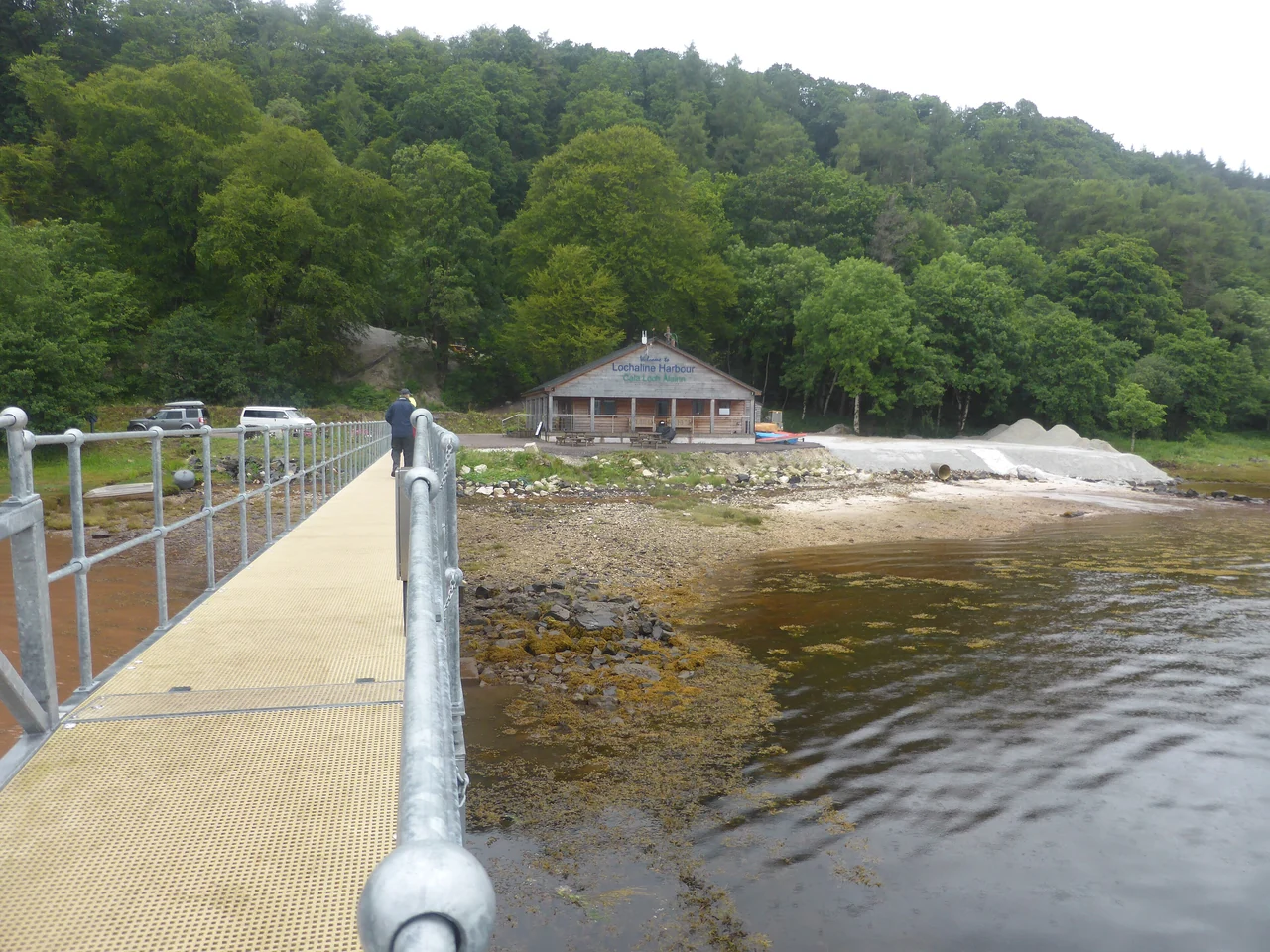
A gangway links the pontoon to the shore, with the harbour building and woodland behind.
Lochaline’s gangway and harbour building · 10 July 2016.Access ramp to the pontoon
Photo: David Medcalf

A village, a sand mine and a sauna

The walk from the pontoons into the village passes a working silica-sand mine. Along this quiet shore, industry sits beside woodland, small boats and the ferry crossing to Fishnish on Mull. In the village, the Hub Café offers coffee and lunch; back by the harbour, a wood-fired sauna stands at the water’s edge.

The harbour has showers and laundry, a covered gathering place and bikes to hire. The harbour team arranges sauna bookings and can explain the local walks and cycle options.

Lochaline Harbour and village visits ↗ The community harbour’s story

Where boats gather

Tobermory:
a town made for its harbour.

Near the northern end of the Sound, Tobermory’s coloured waterfront curves around the bay, with woodland climbing behind it. Yachts lie among local boats and passenger vessels. The town’s main street follows the water, putting shops, pubs and places to eat close to a berth or dinghy landing.

The harbour came first

The British Fisheries Society founded Tobermory in 1788 as a planned fishing settlement. Making room for its waterfront involved cutting into the slope and reclaiming ground from the sea. The harbour’s usefulness explains the shape of the town: buildings crowded along a narrow strip of shore, with streets climbing the hill behind.

That relationship continues through community ownership. Tobermory Harbour Association began in 1983 and has developed the pontoons and shore facilities as local infrastructure, reinvesting in the town. The berths and shore facilities used by visiting crews are part of that local enterprise.

How Tobermory was built ↗The community’s harbour ↗

Main Street and the waters beyond

The small Mull Museum on Main Street explores the island’s history. Nearby, the Hebridean Whale Centre brings the surrounding sea into focus through local sightings and research on whales and dolphins. The waterfront is also a departure point for excursions towards Staffa and the Treshnish Isles.

Mull Museum ↗Hebridean Whale Centre ↗
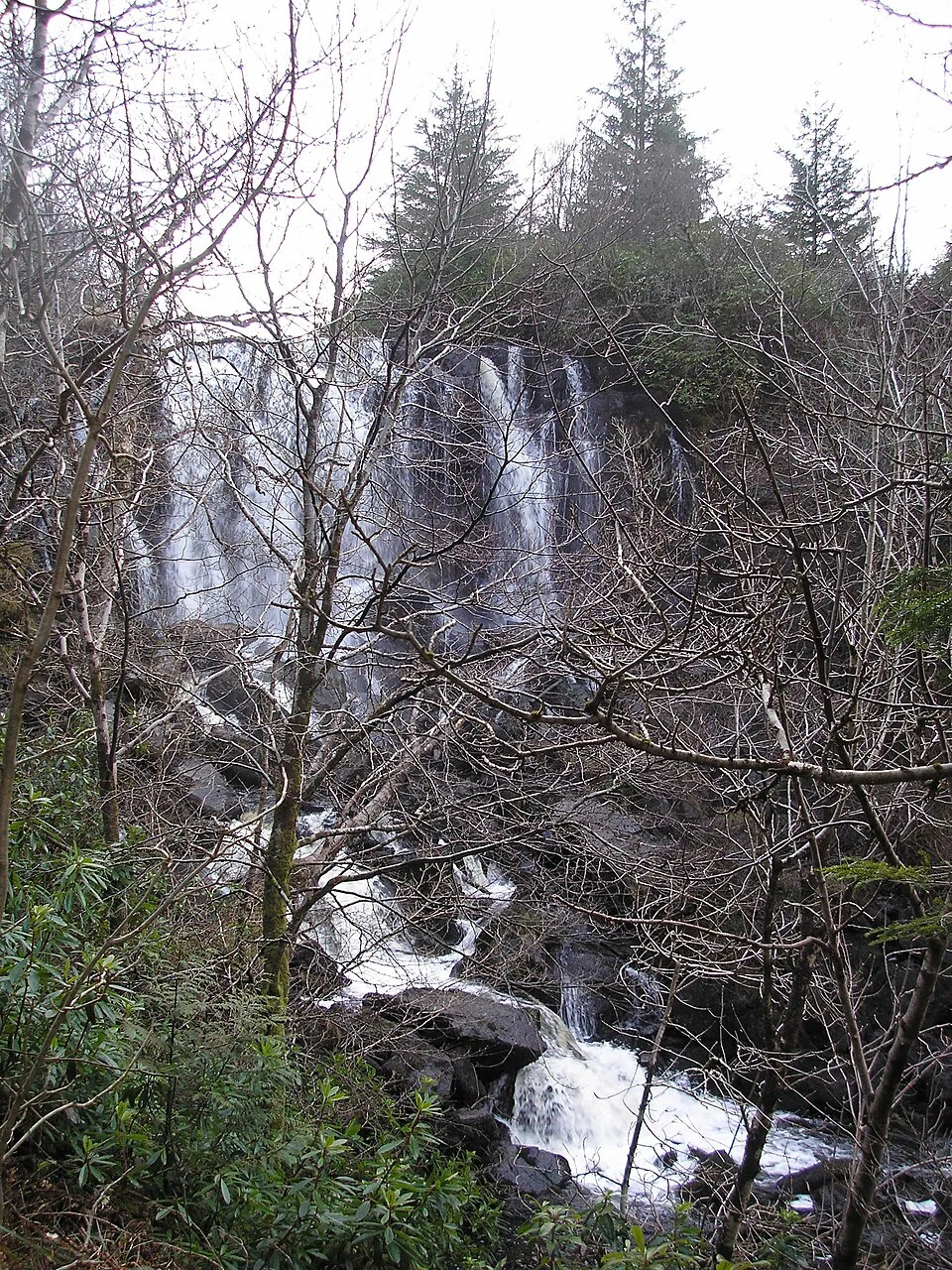
Water cascades between trees and rocks at the upper waterfall in Aros Park.
The upper waterfall in Aros Park · published 20 April 2006; capture date unknown.
Photo: Chris Haikney

Beside Tobermory

Aros Park: into the woods from the waterfront

The coastal path from the harbour reaches Aros Park in about 2 km. The town gives way to woodland, waterfalls and views across the bay: a walk from the boats into the landscape behind them.

Forestry work began on 31 August 2026, with an expected duration of four weeks. The park remains partly open, but work areas and sections of the coastal path can close; the current notice gives the access arrangements.

Aros Park and access notices ↗
North along the coast, or west around Mull?

Beyond Tobermory, a northbound boat can continue towards Ardnamurchan and the Small Isles. Following Mull’s northern coast west leads into a different setting. The mainland no longer forms the opposite shore, the horizon widens and the Atlantic has a greater part in the sailing. Tobermory is both a harbour to enjoy and a place where these two directions meet.

Explore Skye and the Small Isles →

The Atlantic coast

West Mull:
the landscape opens.

Along western Mull, cliffs and rocky coves alternate with sandy bays, and small islands stand against an open sea horizon. Loch na Keal reaches inland beneath the island’s mountains. Farther out, the waters around Staffa and Treshnish are home to seals and dolphins, with seasonal visits by minke whales and basking sharks.

The remains of a volcanic landscape

Much of north and west Mull was built from successive lava flows. The layers extend into Ulva, Staffa and the Treshnish Isles: separate islands today, but parts of a much larger volcanic landscape worn down by time and the sea. Staffa’s columns belong to the same story as the dark cliffs and stepped hills of Mull.

The geology of Mull and its islands ↗
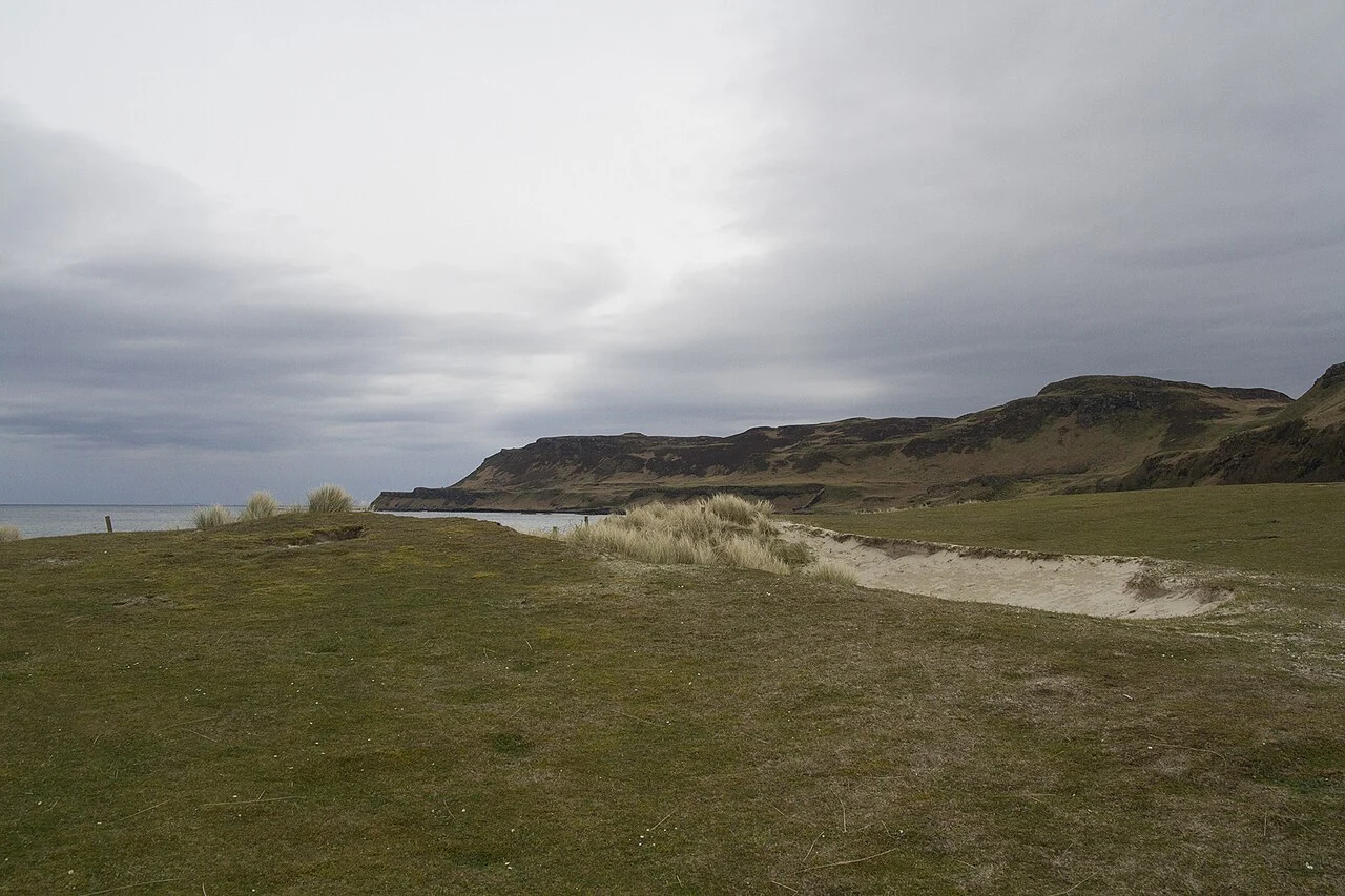
Pale sand and grass at Calgary Bay, with low hills and clouds over the bay.
Calgary Bay’s sandy beach under a grey sky · 5 May 2015.Calgary Bay, Mull
Photo: Malcolm Neal

The northwestern shore

Calgary’s pale sand

Calgary’s beach makes a softer interruption in this rocky coast: pale sand and a grassy shore beneath low hills. It also brings the western landscape within reach of a stay in Tobermory. The bus crosses the island to the bay, so the yacht can remain in the harbour.

The visit by road

West Coast Motors lists the Tobermory–Calgary service. The return timetable sets the time available at the beach; prearranged road transport is another option. Calgary Bay Co lists Friday and Saturday closures in 2026.

Mull bus servicesCalgary Bay Co
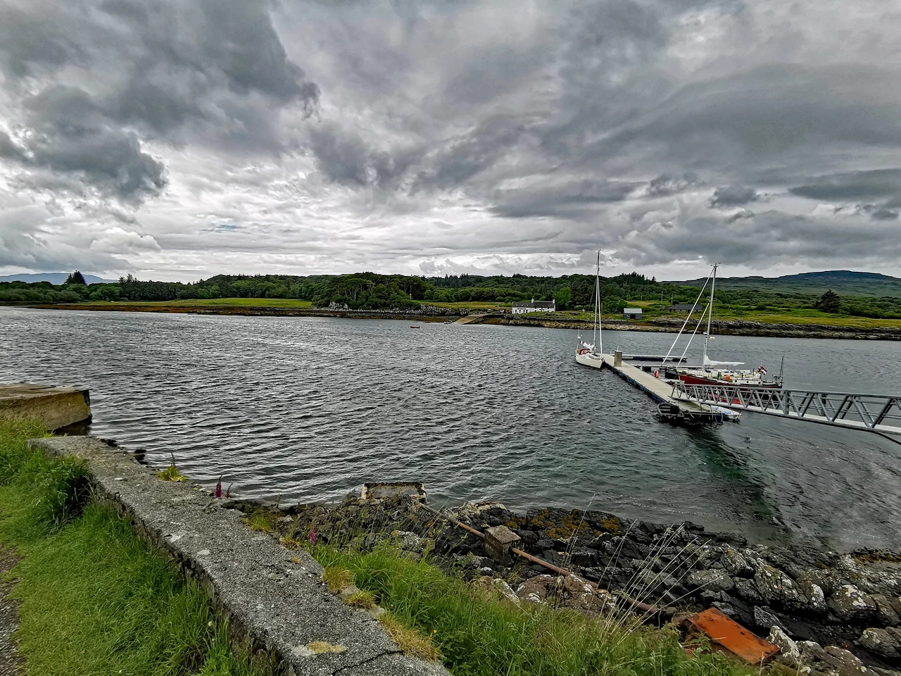
Sailing boats at a pontoon in the sound at Ulva Ferry, beneath dark clouds.
Ulva Ferry on Mull, with boats at the pontoon · 17 June 2019.
Photo: PaulT (GuntherTschuch)

Ulva Ferry and Ulva

A tiny crossing.
An island rebuilding its future.

Ulva had more than 800 inhabitants in the late eighteenth century. Clearances and later depopulation left a much smaller community. In 2018, local people bought the island, with plans to restore homes, create work and bring residents back. The buildings and paths encountered on a walk belong to that continuing story.

The small yacht pontoon is on the Mull side, beside the foot ferry. Across the narrow water, Ulva has woodland walks and the Boathouse by the landing, serving local seafood. A stop here connects a boat journey with an island where community ownership is shaping what happens next.

Ulva’s history and community buyout ↗

In 2026 the passenger ferry runs on demand from 1 April to 31 October, Monday–Friday, weather permitting, with no weekend sailings. Ulva Church and Sheila’s Cottage are closed pending restoration, and Ulva House is not open to visitors. The Boathouse serves on weekdays.

The passenger ferry ↗ Exploring Ulva ↗ The Boathouse ↗

Off western Mull

Staffa:
where rock becomes music.

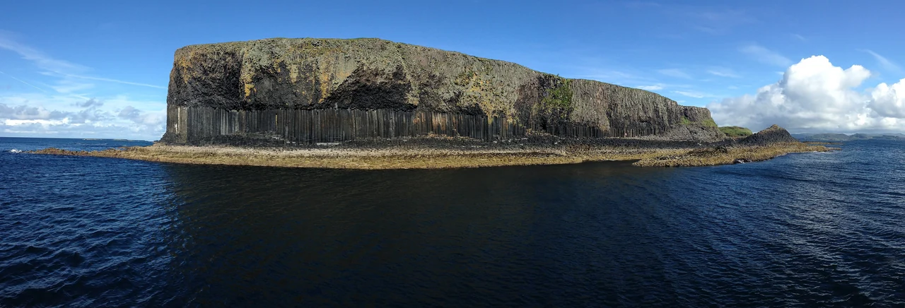
From the sea, Staffa’s black columns look almost built: upright pillars carrying the island above the swell, with the dark opening of Fingal’s Cave at their foot. This small island makes Mull’s volcanic past visible in a form that has drawn travellers, painters and composers for centuries.

Staffa’s dark basalt columns rise above the sea, with the cave opening at the foot of the cliff.
Staffa’s basalt columns and Fingal’s Cave from the sea · 29 July 2015.
Photo: Rosa Menkman

Lava, cooling rock and ocean swell

The basalt formed from lava around 61 million years ago. As the rock cooled and contracted, cracks divided it into columns. The cave came later, as repeated ocean swell worked into weaknesses and broke away pieces of the cliff. Its apparent architecture was made by heat, cooling and the sea.

How Staffa was formed ↗

An island in the European imagination

Mendelssohn’s visit inspired the Hebrides Overture. Turner painted Staffa; Wordsworth and Walter Scott were among the writers drawn here. Rock, echo and moving water became part of Romantic art and music. Arriving from Mull puts that cultural history back into its setting: an offshore island approached across the sea.

Staffa’s history and cultural influence ↗

Seeing Staffa from the water and ashore

The columns and cave are a reason to come out on the water even when a landing is unavailable. Local excursion boats offer a way to visit from a harbour stay on Mull; taking the yacht around the western coast is a more exposed sailing choice. Access ashore depends on sea conditions, and the island’s steps and basalt surfaces are steep and slippery.

September 2026 landing restriction: NTS reports repair works during the week beginning 21 September. While work continues, the jetty and island landing are unavailable unless specific arrangements are made with NTS. A further notice will announce completion.

Staffa access and current Notice to Mariners ↗

The living landscape offshore

Treshnish:
islands filled by the summer birds.

Beyond northwestern Mull, the Treshnish Isles form a scatter of grassy islands, sea stacks and skerries. Their silhouettes belong to the view from the western coast. In the breeding season, coming closer reveals another landscape altogether: ledges occupied by seabirds and puffins returning to burrows above the shore.

Lunga and Harp Rock

On Lunga, a short walk from the usual landing reaches the puffin colony. Farther around the shore, Harp Rock rises across a deep cleft, with guillemots, razorbills, shags and kittiwakes crowding the rock in summer. The appeal is the closeness of the island world: grass, basalt, birds and the sea all around.

This is a seasonal encounter. Puffins come ashore to breed and spend most of the year at sea; a late-season visit has a different character from the summer colonies. Some excursions from August sail around Treshnish without landing on Lunga.

Lunga has no visitor facilities, toilets or formal footpaths. Landings depend on weather and sea conditions, and the ground is rough with steep drops. NTS does not permit dogs apart from assistance dogs, and marked boundaries protect nesting areas.

The seabirds of Treshnish ↗Visiting Lunga and the Treshnish Isles ↗
Excursions from Tobermory

Staffa Tours sails from Tobermory towards Staffa and Treshnish. Its late-season excursion describes a cruise around the Treshnish Isles rather than a Lunga landing. The exact island calls and landing opportunities depend on the season, current notices and sea conditions.

Staffa Tours: the excursion from Tobermory

Farther south, off Mull’s southwestern tip

Iona across the sound.

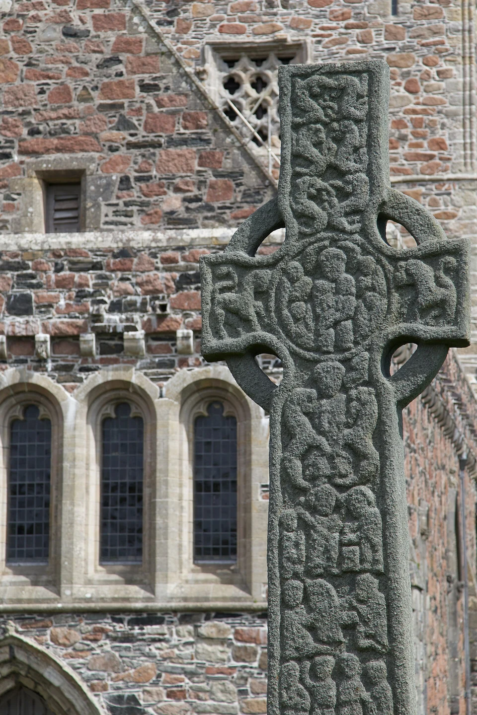
Iona brings another kind of island history to the waters west of Mull. The abbey and its museum of carved stones stand beside a small island community, reached by ferry from Fionnphort at the end of the Ross of Mull.

A carved stone cross, a replica, stands in front of Iona Abbey’s windows and stone wall.
Iona Abbey. The carved cross in front is a replica · 23 July 2015.
Photo: Tom Parnell

The abbey and the island shore

The abbey buildings and carved stones give the visit a focus, while the crossing places them in their island setting. Iona is a separate journey from Tobermory: by land it means travelling across Mull to Fionnphort, then taking the passenger ferry. From Oban, organised trips combine the Craignure ferry, a bus across Mull and the Iona crossing.

Ferries and abbey visits

The combined excursion from Oban occupies a full day; abbey admission is additional. CalMac publishes the Fionnphort–Iona sailings, and Historic Environment Scotland lists abbey opening and tickets.

Fionnphort–Iona ferryIona Abbey and NunneryMull and Iona excursion from Oban

Connections on the mainland

Oban, Kerrera
and Dunstaffnage.

Oban joins the Sound of Mull to the mainland railway and ferry network. Trains arrive from Glasgow Queen Street; the Craignure ferry and bus across Mull continue towards Tobermory. For a yacht, the Oban area also offers visitor berths and yards before or after exploring the islands.

Arriving from Glasgow and continuing to Mull

Glasgow Airport’s 500 bus connects with the city centre. The train for Oban leaves from Queen Street. The final transfer depends on the berth; Tobermory adds the Oban–Craignure ferry and a bus journey across Mull.

Glasgow Airport Express 500Queen Street–Oban trainsOban–Craignure ferryMull buses

Dunstaffnage

Kerrera Marina

Kerrera’s marina puts visitor berths, an island restaurant and boatyard services across the water from Oban. Its prebooked water taxi takes about ten minutes from North Pier. The Gallanach ferry serves southern Kerrera, a different part of the island.

Oban and KerreraNorth Pier and Kerrera Marina lie north of the separate Gallanach–Kerrera ferry connection.Oban and KerreraPlaces to choose fromDunstaffnageKerrera MarinaNorth PierObanKerreraFerry landingGallanachNorth: booked marina water taxi.South: separate Gallanach ferry.2 kmN© OpenStreetMap contributors
North: the marina water taxi from North Pier. South: the separate Gallanach ferry.
Book the marina water taxiThe separate Gallanach–Kerrera ferry
Sources and further reading

Harbour operators, island communities and visitor information are linked beside each place. These additional sources explore the history and landscapes behind the guide.

Photo sources · Seven photographs

Photographer, date, source and licence accompany each photograph.

The Aros photograph’s capture date is unknown. The carved cross in front of Iona Abbey is a replica.

Tobermory

Tobermory waterfront

DeFacto · 18 June 2016.

Licence

Calgary

Calgary Bay, Mull

Malcolm Neal / Geograph · 5 May 2015.

Licence

Ulva

Mull Ulva Ferry 1

PaulT (GuntherTschuch) · 17 June 2019.

Licence

Iona

Iona Abbey – view of abbey and replica carved stone

Tom Parnell · 23 July 2015.

Licence

Aros

Aros Falls near Tobermory

Chris Haikney · published 20 April 2006; capture date unknown.

Licence

Lochaline

Access ramp to the pontoon

David Medcalf / Geograph · 10 July 2016.

Licence

Staffa

Fingal’s Cave, Staffa

Rosa Menkman · 29 July 2015.

Licence

Coastlines and place data: © OpenStreetMap contributors, acquired 18 September 2026. The map data is available under ODbL and the cartography under CC BY 4.0.