Vineyard coast · lagoons · working waterfronts
Côte Vermeille & western Golfe du Lion
The mountains disappear. Behind the beach, another coast comes into view.
North of the Spanish border, vineyards still climb the rocky folds of the Pyrenees. Cerbère, Banyuls, Port-Vendres and Collioure share the Catalan coast’s close relationship between hills, boats and town. At Argelès the landscape opens: sand stretches towards Leucate and Gruissan, with lagoons behind it. Fishing huts, salt pans and shellfish farms give this low coast its substance. Sète brings the sea and lagoon worlds together around a working port.
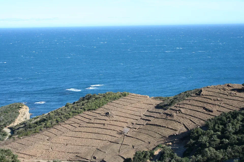
Photo: cocoate.com
Five stretches of coast
Cerbère · Banyuls · Port-Vendres · Collioure
Argelès · Saint-Cyprien · Canet
Port-Leucate · oyster growers · La Franqui
Ayrolle fishing huts · salt pans · volcanic coast
Fishing quays · Pointe Courte · Bouzigues
The rocky south gives way to a long, exposed sandy arc. Harbour entrances punctuate it; much of the life ashore lies beside water hidden from the open sea. The limestone headland at Leucate, volcanic Agde and Mont Saint-Clair at Sète break the low horizon.
Côte Vermeille: the mountains still reach the sea
The border at Cerbère divides countries within a continuous coastal landscape. Catalan place names, food and maritime traditions carry on northwards. Small bays cut into schist headlands, and vines occupy slopes that would otherwise seem too steep to cultivate. The towns are close together but offer very different ways of spending time ashore.
Cerbère & Banyuls: cultivated hills, studied seas
At Banyuls, the dry-stone terraces are a working landscape. Schist walls hold soil on the hillside, while stone drainage channels guide water through the vineyards when heavy rain arrives. The same slopes produce the wines of Collioure and Banyuls; a tasting gains context from a walk above the town, where the effort of holding this ground in place becomes visible.
Down by the waterfront, Biodiversarium connects its aquarium with the research of the Observatoire Océanologique. Rocky seabeds and seagrass habitats belong to the water just outside. Between Cerbère and Banyuls, the marine reserve created in 1974 adds a longer conservation story. In season, the underwater trail at Peyrefite lets swimmers follow that story from the beach. The marked trail normally operates from June to September.
For the rocky bays, use the marine park’s current regulations: reserve zones have different anchoring, fishing and diving rules. The park extends from Cerbère to Leucate, beyond the smaller Cerbère–Banyuls reserve.
Port-Vendres: a town around its working harbour
Port-Vendres opens into a deeper fold of the coast. Cargo traffic, fishing boats and visiting yachts share the harbour, with houses rising above the quays. The commercial waterfront is part of the town’s identity; around the fish port and quays, the Côte Vermeille’s connections across the Mediterranean remain tangible.
The Mallorcan trading schooner Miguel Caldentey gives that history a particular boat. Built in the early twentieth century, she belongs to the era when sailing cargo vessels linked the Balearics, Catalan ports and North Africa. Her restoration project is based at Port-Vendres. Public visits depend on the project’s programme; this is a vessel under restoration, rather than a permanently open floating museum.
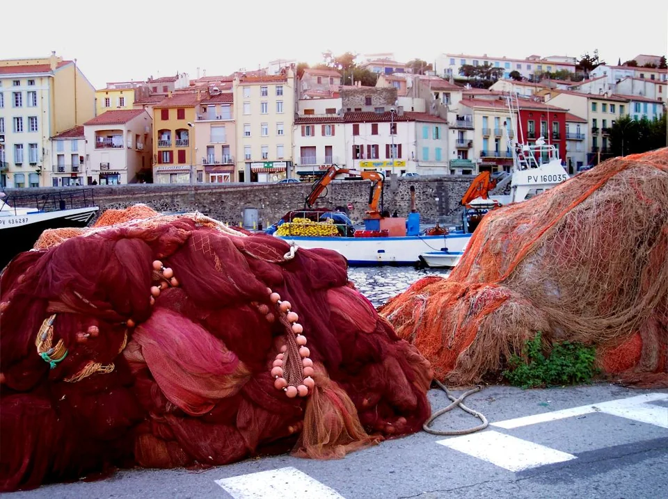
Photo: Palauenc05
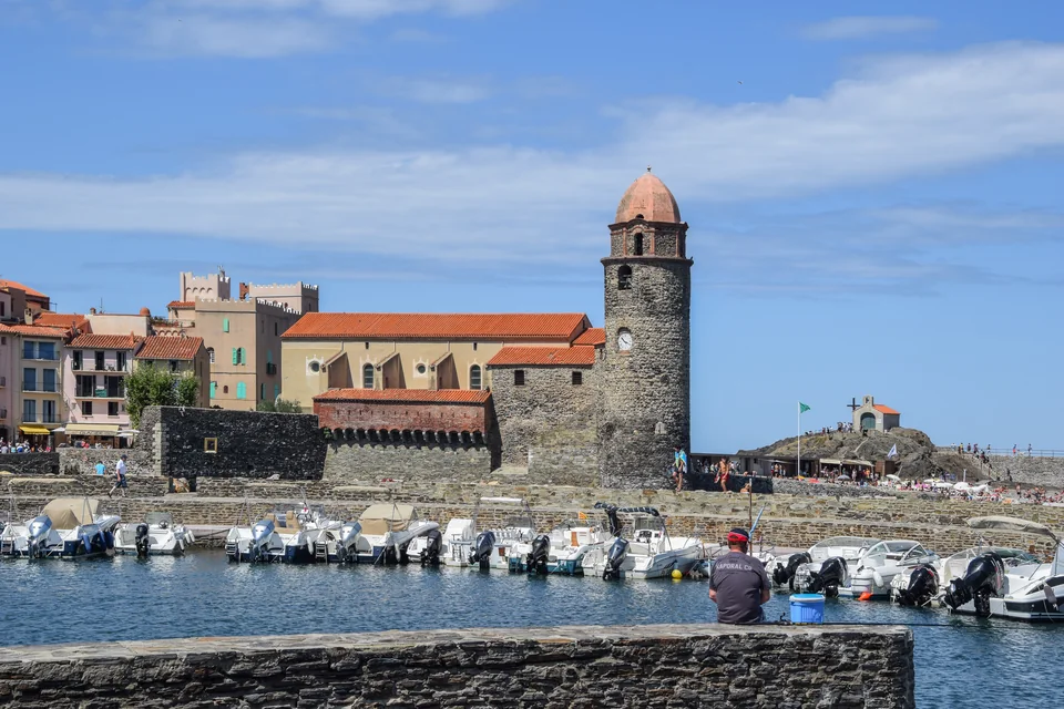
Photo: Krzysztof Golik
Collioure: colour, anchovies and a small bay
Collioure gathers castle walls, the church tower and small beaches into a compact waterfront. Matisse and Derain worked here in 1905, when their use of colour helped form Fauvism. The Chemin du Fauvisme places reproductions around the town: it lets you compare painted views with the harbour and streets themselves.
Anchovy curing carries another part of the town’s history. Salt, time and hand preparation turn a small fish into a local speciality; established producers such as Maison Roque continue the trade. A shop visit or tasting connects the harbour’s fishing past with something still made and sold here.
Where the mountains withdraw
Argelès & the Roussillon plain
At Argelès, the last rocky bays give way to a beach that runs north beside the Roussillon plain. The Albères remain behind the town, but the shore ahead is low. Here the harbour landscape changes too: yacht basins are built into a sandy coast, with breakwaters and entrance channels taking the place of natural coves. Argelès’ old village sits inland; the port and beach form a separate seaside centre.
The coast’s modern resorts are part of its history. Saint-Cyprien’s harbour opened during the major coastal development of the 1960s; its basins made room for a scale of recreational boating the small rocky ports could never have accommodated. Canet developed its own harbour and boat-service economy. Beaches, apartment buildings, repair yards and waterfront restaurants belong to this newer maritime landscape.
Oniria, the aquarium at the port, adds an indoor shore visit; the lagoon and old village belong to a wider excursion inland and south of the harbour.
Leucate: sea outside, lagoon behind
A narrow strip of land separates the Mediterranean from the Étang de Salses-Leucate. Open beaches face east; shallow lagoon water spreads behind them, with low islands and channels along the barrier. Port-Leucate occupies the developed eastern edge of this system, connected to the sea through an entrance channel. Farther north, the limestone plateau and cap lift the land above the water again.
A meal beside the growers’ sheds
At the oyster-growing centre, sheds and tasting terraces line the grau, the channel between lagoon and sea. Oysters and mussels make the relationship between these two waters visible on the plate. The waterfront here is a place of production as well as eating: boats, handling areas and rows of modest buildings explain what the flat coast supports.
The oyster centre lies between Port-Leucate and Leucate-Plage. It is an excursion ashore from the marina; the working quays do not imply visitor yacht berths. Leucate village sits farther inland below its ruined castle, while paths over the cap give a view back across the barrier and lagoon.
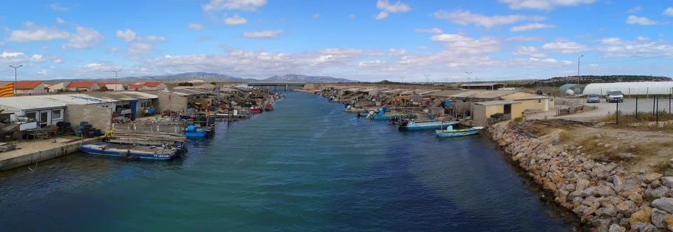
Photo: H. Zell
A coast shaped by wind sports
The Tramontane gives this coast more than a weather pattern. At La Franqui, below the northern side of the headland, windsurfing, kitesurfing and foiling have built their own shore culture around schools, shops and the broad Coussoules beach. The offshore wind can leave water close to the beach looking deceptively flat while blowing hard. A southeast marin brings a different coast, with waves arriving from the open gulf.
Gruissan to Agde: fishing, salt and a volcanic interruption
North of Leucate, the sandy shore continues past La Franqui and Port-la-Nouvelle towards the Narbonnais lagoons. Gruissan brings their different uses close together: an old village around a rocky knoll, fishing huts beside shallow water, salt works on the edge of Saint-Martin and a modern yacht harbour nearer the sea. The low coastline has considerable depth once you leave the outer beach.
Ayrolle: a living fishing shore
At the Ayrolle lagoon, the fishermen’s huts belong to a working settlement. Nets, small boats and direct fish sales connect visitors with a fishery adapted to shallow water. The lagoon exchanges water with the sea through the natural grau of La Vieille Nouvelle; wind helps drive that exchange. Fish move between the two environments, and the fishing places follow the channels and seasonal movements.
The local account of the huts describes Gruissan’s prud’homie, the fishermen’s institution that manages professional affairs and disputes. Its billette is a drawing of lots for fishing positions. This is a useful glimpse of how a shared stretch of water is organised by the people working it. At the Ayrolle sales point, the catch and opening depend on season, weather and landings.
Salt pans & the old village
At the Salin de l’Île Saint-Martin, shallow basins, banks and channels use sun and wind to concentrate seawater. Pale salt heaps and, at times, pink water make a geometric landscape quite different from a natural lagoon. Visits explain the production cycle; the colours vary with season and conditions. The village’s circular streets and Tour Barberousse sit nearby on higher ground, a compact contrast to the spread of basins.
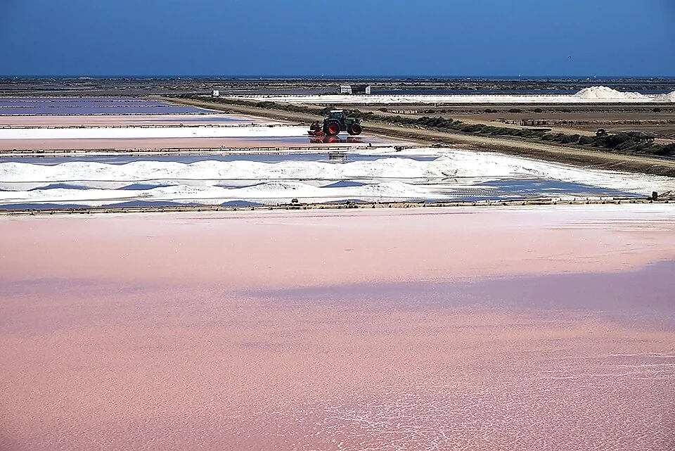
Photo: Isabelle Cheret / Ifremer
Across the sandy arc to Agde
East of Gruissan, Saint-Pierre-la-Mer and the mouth of the Aude lead towards Valras and Sérignan. These are river mouths, resort beaches and harbour entrances along an otherwise low shore. At Agde, dark volcanic rock interrupts the pattern. The cliffs and black sand of La Grande Conque make the change especially clear from a walk above the water. Inland, old Agde stands on the Hérault; Cap d’Agde’s yacht basins are a separate coastal development.
Sète & Thau: a port between two waters
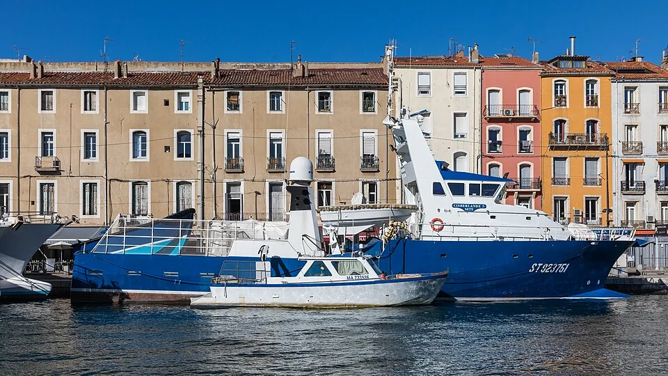
Photo: Raimond Spekking
A town made around a port
Sète’s port was founded in 1666 as the Mediterranean outlet for the Canal du Midi project. Its position explains the city: the sea in front, Thau behind, and Mont Saint-Clair rising between them. Canals pass through the town, and boats occupy its central spaces. Commercial shipping, fishing and yacht basins still make this a working maritime city.
Around the Canal Royal and the fishing quays, the town is easiest to understand on foot. The market halls connect the catch and lagoon produce with the table; tielle, the local octopus pie, belongs to Sète’s food culture. Above the waterfront, the Quartier Haut climbs towards viewpoints, the Musée Paul Valéry and the marine cemetery. The town’s museums and cultural sites bring in poetry, painting and the songs of Georges Brassens alongside the port.
The Halte Nautique at Quai du Pavois d’Or belongs to the canal side. For a yacht continuing towards Thau, fixed and opening bridges, air draught and passage arrangements form a separate access question; a sea-marina booking does not settle it.
Pointe Courte & the lido
On the lagoon side, Pointe Courte has a smaller scale: fishermen’s houses, narrow lanes and boats on the edge of Thau. It is a lived-in neighbourhood, with the working water close to the door. Beyond Mont Saint-Clair, the long lido separates the lagoon from the open Mediterranean towards Marseillan. From the beach, Thau can be almost invisible; from its inner shore, the farms and towns form another waterfront altogether.
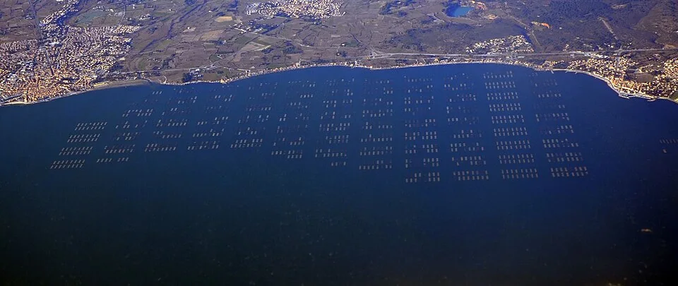
Photo: Sandervalya
Bouzigues: how the lagoon reaches the table
The structures across Thau are shellfish-growing tables: oysters and mussels hang from lines below them. With little tidal range, cultivation works vertically in the water rather than on an Atlantic foreshore exposed at low tide. From Bouzigues’ waterfront, the orderly rows give scale to the lagoon and to the work behind a plate of oysters.
The Musée de l’Étang de Thau explains fishing and shellfish cultivation. Growers’ tastings and organised boat visits to the farms offer other ways into the same landscape. Bouzigues, Mèze and Marseillan give the lagoon distinct town waterfronts. They can be explored ashore from Sète; visiting the farms does not require taking a sea-going yacht through the canals.
Beyond Sète, and back towards Catalonia
East of Sète, Frontignan continues the beach-and-lagoon coast towards Palavas-les-Flots and La Grande-Motte. Le Grau-du-Roi and Port Camargue then form the entrance to the Camargue coverage. In the other direction, Cerbère and Portbou connect the Côte Vermeille with the rocky Catalan coast and Cap de Creus.
Landscape, sources & map credits
Local links beside each place lead to harbour operators, producers, museums and protected-area authorities. For the wider landscape, see INAO on Banyuls, the Golfe du Lion marine park and Sète and the Thau archipelago.
Maps: © OpenStreetMap contributors, data under ODbL 1.0; composition sol.blue. Geographic data: coastal land · lagoons.