Scotland · Cruising grounds

Outer Hebrides

The Long Island between the Minch and the Atlantic.

Cross west from the Inner Hebrides and another island world comes into view. Along its eastern shores, rocky sea lochs, fishing villages and community harbours give visiting boats places to stop and explore. Across the islands lie shell-sand beaches, crofting land and the open Atlantic.

That meeting of inhabited shores and ocean-facing landscape is the great attraction of sailing here. A boat brings you into the communities; roads, paths and further sea passages reveal very different sides of the same islands.

Explore the Long Island ↓
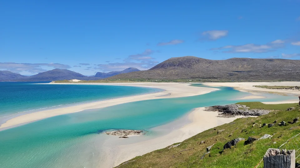
Pale sandbanks curve through turquoise water at Luskentyre, with the hills of Harris beyond.
Luskentyre, on the western side of Harris · 31 May 2023.
Photo: Scotboy19

Finding your bearings

One island chain.
Two ways to meet the sea.

Outer Hebrides · north and south The Outer Hebrides extend from Barra and Uist in the south to Harris and Lewis in the north. Eastern harbours face the Minch and Sea of the Hebrides; the western shores face the Atlantic. Skye lies across the water to the east. Outer Hebrides · north and south Harbours, villages and island shores Stornoway Newton Lewis Harris Tarbert (Harris) Scalpay Lochmaddy Lochboisdale Castlebay Barra Uist Skye 20 nautical miles · at 57.7° N N © OpenStreetMap contributors · ODbL The Minch Atlantic Ocean Sea of the Hebrides
© OpenStreetMap contributorsMap data · ODbLOriginal map design: Sophie · CC BY 4.0

The Outer Hebrides form a long barrier between the Minch and Sea of the Hebrides to the east and the North Atlantic to the west. Barra and Uist occupy the southern part of the chain; Harris and Lewis share the large northern landmass. Their harbours, ferry links and Gaelic-speaking communities give the “Long Island” a life that runs along its length.

The eastern shores

The eastern coast gathers the main yacht harbours and many deeply indented sea lochs. Crossings from Skye, the Small Isles or Mull still involve open water, but once across, there are villages and anchorages to explore along the island side of it. Castlebay, Lochboisdale, Lochmaddy, Tarbert and Stornoway each open onto a different part of the islands.

The Atlantic side

The western shores face ocean swell, with broad beaches, offshore islands and fewer developed yacht facilities. Many of those beaches are also reachable across the islands by road: an eastern harbour can be the starting point for exploring the Atlantic coast ashore. Taking the yacht west opens further possibilities, particularly around Harris and Loch Roag, with a different exposure to the sea.

Barra and Vatersay
Castlebay’s community marina, a castle in the bay and beaches across the causeway.
Uist
Eastern sea lochs and harbours; western machair, crofts and long beaches.
Harris and Scalpay
Rocky bays, mountain-backed sands and the island’s weaving industry.
Lewis and Stornoway
A working maritime town, Calanais and the branching waters of Loch Roag.

Farther west, St Kilda stands apart from the inhabited chain. Its isolation makes a visit a separate Atlantic undertaking.

The voyage to St Kilda ↓

The southern islands

Barra: a village gathered around its bay.

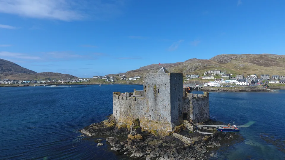
Kisimul Castle stands in Castlebay, with the village and hills around the shore.
Kisimul Castle and Castlebay · 21 April 2017.
Photo: Conor Lawless

Arriving beneath Kisimul

Castlebay makes a memorable southern landfall. Kisimul rises from a rocky islet in the bay, with the houses of the village spread around the water. The ferry, fishing boats and visiting yachts share the setting; shops and places to eat are part of a working island settlement.

The marina is run by a community-owned social enterprise, with its income reinvested locally. Going ashore here connects a visiting boat directly with village life. Farther around Barra, crofts and small settlements sit between rocky ground, beaches and the sea.

The castle in the water

Kisimul was the island stronghold of the MacNeils of Barra. Seen from the waterfront, its walls explain how closely power and sea travel were connected in these islands. An interior visit is a separate boat excursion from Castlebay: Historic Environment Scotland offers selected guided visits with the transfer included, booked in advance. Conservation work limits access to parts of the castle.

Kisimul: available visits and access
An airport on the beach

At the northern end of Barra, scheduled aircraft land on the sands of Traigh Mhòr. The runway disappears beneath the rising tide, so flight times move with the sea. The flights provide a lifeline connection with Glasgow. The airport has a café; the beach is an active airfield when flights are operating.

Barra Airport
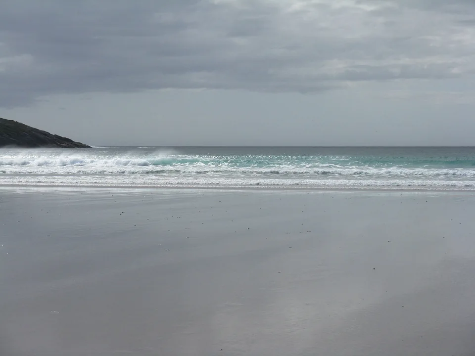
Atlantic waves roll onto the pale sand of Vatersay’s western beach beneath a grey sky.
The western beach at Vatersay · 3 August 2015.
Photo: M J Richardson

Two beaches across the causeway

A narrow neck of land separates Vatersay’s east- and west-facing beaches. On the western shore, Atlantic waves reach Bàgh Siar; over the grass lies another bay facing the other way. The island is joined to Barra by a causeway, so these shores can be explored overland from Castlebay.

The W33 bus links Castlebay and Vatersay, with some journeys requiring advance booking and no Sunday service in the published 2026 timetable. Cycling or a taxi offers other ways across.

Barra and Vatersay bus timetables

South towards Mingulay

Beyond Vatersay, the Barra Isles continue south through a wilder seascape. Mingulay combines great seabird cliffs with the remains of a village whose last residents left in 1912. Berneray, also called Barra Head, marks the southern end of this island group. Local excursion boats from Barra offer access to these shores; Mingulay landings depend on sea conditions.

Mingulay and the southern islands: visiting

Lochs, crofts and machair

Uist: a landscape made of water.

Across Uist, fresh water and salt water divide the land into an intricate patchwork. Rocky hills and sea lochs shape the eastern shore; the west opens into low grassland and long Atlantic beaches. Causeways connect Eriskay, South Uist, Benbecula, Grimsay, North Uist and Berneray, making it possible to explore much of this landscape ashore from an eastern harbour.

Barra and Uist Barra and Uist, with Castlebay, Vatersay and Mingulay in the south; Eriskay, Lochboisdale and Lochmaddy farther north. Vatersay is linked to Barra by road. Barra and Uist Harbours, villages and island shores Lochmaddy North Uist Benbecula South Uist Lochboisdale Eriskay Barra Castlebay Vatersay Mingulay Road connection Atlantic Ocean 10 nautical miles · at 57.2° N N ◆ Vatersay by road · ◇ Mingulay by boat © OpenStreetMap contributors · ODbL Barra and Uist Barra and Uist, with Castlebay, Vatersay and Mingulay in the south; Eriskay, Lochboisdale and Lochmaddy farther north. Vatersay is linked to Barra by road. Barra and Uist Harbours, villages and island shores Lochmaddy North Uist North Uist Benbecula South Uist Lochboisdale Gasay harbour Eriskay Working harbour Barra Castlebay Vatersay Mingulay Road connection Atlantic Ocean 10 nautical miles · at 57.2° N N ◆ Vatersay by road · ◇ Mingulay by boat © OpenStreetMap contributors · ODbL

Eriskay and the story behind Whisky Galore

Eriskay sits between Barra and South Uist, beside the tidal waters of the Sound of Barra. In 1941 the cargo ship Politician ran aground nearby with a cargo that included whisky. Islanders salvaged bottles, customs officers intervened, and the events later inspired Compton Mackenzie’s novel Whisky Galore and its film adaptations. The wreck belongs to island history; the comic tale is its later retelling.

Eriskay’s history

Along the eastern sea lochs

Between the developed harbours, inlets such as Loch Eynort and Loch Skipport take boats into a quieter coast of rocky hills, scattered settlement and natural anchorages. The water reaches far into the land. These are part of Uist’s attraction in their own right, alongside the practical stops at Lochboisdale and Lochmaddy.

Sailing around Uist
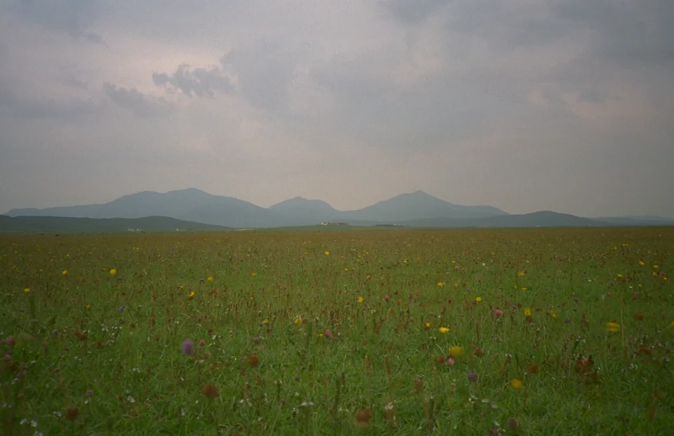
Wildflowers cover South Uist’s machair, with low hills beneath a clouded sky.
Flowering machair on South Uist · 1995.
Photo: Tim Niblett

The flowering Atlantic shore

Machair is the low, fertile coastal grassland behind many western beaches. Atlantic winds carry crushed shell sand inland; grazing and generations of cultivation have helped shape the resulting mosaic of dunes, fields and flower-rich ground. On Uist, the scale of it becomes unmistakable: long pale shores with cultivated land and grassland behind them.

Crofting remains part of ordinary working life. Fields, livestock and small settlements give the open landscape its pattern. Around Howmore and Askernish on South Uist, or Balranald on North Uist, a trip across from an eastern harbour reveals this Atlantic side of the islands. The flower display changes through summer, with the main season from mid-June to mid-August.

Beaches and machair across the islands
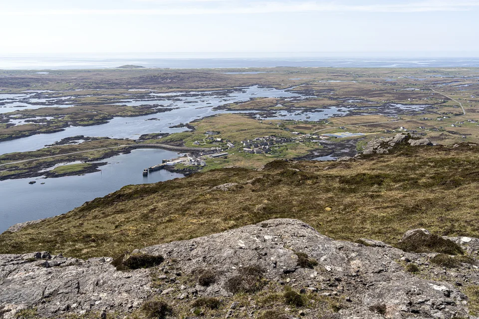
Lochboisdale and its sea loch seen from the hill of Beinn Ruigh Choinnich.
Lochboisdale from Beinn Ruigh Choinnich · 15 May 2025.
Photo: John Knight

Lochboisdale: a harbour built for the community

The harbour at Gasay opened in 2015 as part of the community-owned Stòras Uibhist estate. Yacht pontoons, a commercial quay and marine services belong to the same development. The development serves commercial boats alongside visiting yachts, with profits reinvested locally.

Paths connect Gasay with the old pier, with views across the sea loch and local places for food and supplies. The western beaches are an outing across South Uist, requiring onward transport from the harbour.

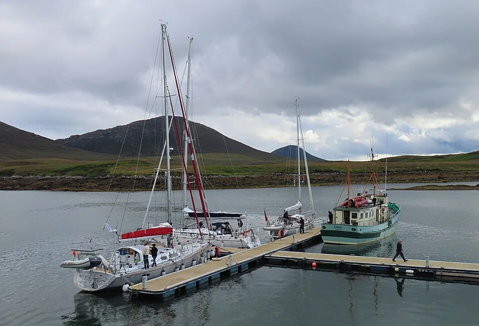
Yachts lie at the pontoons in Lochmaddy, with low rocky shores around the bay.
Lochmaddy marina, North Uist · 5 August 2023.
Photo: Anne Burgess

Lochmaddy: services and island culture

Lochmaddy brings village life to the eastern edge of North Uist’s watery landscape. Its ferry connection with Skye and marina make it a practical point of arrival or replenishment. Taigh Chearsabhagh adds a museum, galleries and café, with exhibitions and collections rooted in the islands’ art, language and history.

Gaelic remains a language of everyday life across the Outer Hebrides—in homes, schools, music and conversation. In places such as Taigh Chearsabhagh, that living culture is part of what visitors encounter alongside the older island stories.

Taigh Chearsabhagh: exhibitions and visits

The sounds through the chain

The Sound of Barra and Sound of Harris open between the island groups. They connect the eastern waters with the Atlantic side through passages broken by islands and reefs. The Sound of Harris lies between North Uist and Harris; Leverburgh and Berneray face one another across its ferry route. Strong, variable tidal streams make the timing of a passage significant.

Sound of Harris: local sailing information

West of Uist: the Monach Isles

Off North Uist’s western shore, the low Monach Isles extend the landscape of sand and machair into the Atlantic. Their remoteness and seal colonies give them a different character from the eastern sea lochs. Visiting by sea involves the exposed western coast and a suitable opportunity to land.

The Monach Isles

The rocky Bays and the western sands

Harris: across the island, another coast.

Harris’s eastern Bays form an intricate coast of bare rock, inlets and small settlements. On the west, broad shell-sand beaches lie below the hills, with turquoise shallows opening towards Taransay and the Atlantic. Tarbert sits at the narrow waist between East and West Loch Tarbert.

Tarbert: ashore at the island’s waist

The yacht pontoons lie on the eastern side, beside the village and ferry harbour. Shops and places to eat are close by; the Isle of Harris Distillery stands at the head of the bay. From here, roads lead south towards Luskentyre and the west-coast beaches, around the eastern Bays or north into the hills and Lewis.

Scalpay: a fishing island beside Harris

Scalpay lies at the entrance to East Loch Tarbert, joined to Harris by a bridge. Fishing remains central to its identity, and the visitor pontoons sit in North Harbour among the island’s working waterfront. The North Harbour Bistro is close to the water; farther across the island, the walk towards Eilean Glas lighthouse leads onto open coastal ground.

Eilean Glas: paths and access

Cloth woven in island homes

Harris Tweed ties an international industry to the islands. The wool is dyed and spun in the Outer Hebrides, the cloth is handwoven by islanders at home, and finishing also takes place here. The name extends beyond Harris: weavers across the Outer Hebrides belong to the same protected tradition.

In a weaver’s loom shed, the cloth takes shape on a hand-operated loom. The Harris Tweed Authority’s trail identifies weavers, shops and places telling the cloth’s story; individual workshops need an arrangement before visiting. In Tarbert, tweed shops are close to the pontoons, while Stornoway has the Authority’s Story Room.

Harris Tweed: weavers and places to visit

The Shiants, out in the Minch

East of Harris, the Shiant Isles rise from the Minch in dark cliffs. Their summer seabird colonies give a reason to leave the coast and explore these offshore islands. Yachts and local excursion boats approach across open water; the opportunity to land depends on conditions.

The Shiant Isles

A working port and a long human history

Lewis: the harbour town and the stones.

Arriving in a maritime town

Stornoway changes the scale of a cruise along the islands. Fishing vessels, ferries, commercial quays and yacht pontoons belong to the same substantial harbour. The town grew through maritime trade and the herring industry; its connection with fishing and Harris Tweed remains visible in its working life.

The Inner Harbour marina brings visiting yachts into the town centre, close to shops and places to eat. Across the harbour, Lews Castle and Museum nan Eilean provide a wider introduction to the islands. Stornoway is also the chain’s main centre for supplies, transport and marine support, with roads west to Calanais and north towards Ness.

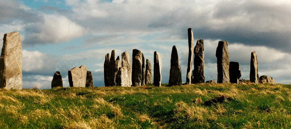
Tall weathered stones stand on a grassy ridge at Calanais beneath a clouded sky.
Calanais standing stones, western Lewis · 20 June 2000.
Photo: Marta Gutowska

Five thousand years on a ridge above the water

At Calanais, a tall central stone stands within a circle, with rows of stones extending across the ridge. The main monument was raised between about 2900 and 2600 BC. Smaller circles and other remains nearby place it within a much larger prehistoric landscape. From its elevated setting, the relationship between the land, surrounding water and distant hills is still apparent.

Calanais lies on western Lewis, reached overland from Stornoway. It makes a substantial shore outing from the east-coast marina. Approaching the western sea lochs in the yacht is a separate cruising choice.

Calanais: history and visiting

Loch Roag: Lewis from the west

Great Bernera and smaller islands divide Loch Roag into branching eastern and western waters. This is a broad western cruising area, with rocky shores, sea lochs and fishing and aquaculture activity. Its inlets lead into a different Lewis from the town-facing coast at Stornoway, while its approaches remain open to the Atlantic.

Farther west lie the Flannan Isles, a small and exposed offshore group. They belong to the wider maritime landscape beyond Lewis, with a separate passage and uncertain landing conditions.

Loch Roag and the coasts of Lewis

Ness and the end of the chain

North of Stornoway, small fishing and community piers replace the main marina stops. At the Butt of Lewis the coast turns towards the open Atlantic. The passage around it links the Minch with the exposed north and west coasts, where shelter and services are more dispersed.

Ness also has its own boat tradition. The sgoth Niseach is a wooden fishing boat built with overlapping planks and a dipping lug sail, developed for the local fishery. Their hulls and rigs reflect the work of fishing in these waters.

A Ness fishing boat in the maritime collection

Beyond the main chain

St Kilda: a separate voyage into the Atlantic.

West of Harris and Uist, St Kilda stands alone beyond the inhabited chain. The passage leaves the intervening shelter behind, and the opportunity to arrive and land depends on Atlantic conditions. Some visitors take their own yacht; others join an excursion vessel from the Outer Hebrides.

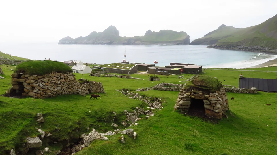
Turf-roofed stone cleits overlook the buildings and anchorage at Village Bay on Hirta.
Cleits above Village Bay, Hirta, St Kilda · 19 May 2023.
Photo: Colin Park

Reading a life shaped by the sea

The cliffs and seabird colonies are only part of the encounter. Around Village Bay on Hirta, houses, field boundaries and small stone stores show how people lived here. Seabirds, sheep, cultivation and collective work supported a community in a place with very little margin between land and ocean.

The cleits are drystone storage buildings whose open-jointed walls allowed air to circulate around food and other supplies. Scattered across the slopes, they make the work of survival visible. The last permanent residents left in 1930, after a much longer history: UNESCO records evidence of more than 4,000 years of intermittent human occupation.

St Kilda’s natural and cultural history

Coming ashore at Village Bay

Village Bay is the point of arrival. The National Trust for Scotland requires people visiting in their own boats to land in an open tender during daylight, as part of measures to keep rats and other unwanted species off the islands. Landing-facility charges apply; current biosecurity requirements and access notices are published by the Trust.

For walks beyond the village, the Trust’s access notice identifies unstable ground following the Conachair landslide and alternative routes towards the hills.

St Kilda: landing, boat trips and current access

Connections with the islands

Joining the boat along the chain.

The ferry ports and airports give several points of arrival, depending on where the boat is lying. Ferry routes also explain why some small settlements have a much larger role in island life.

Barra and southern Uist

Glasgow–Barra flights arrive on the beach runway, with onward road transport to Castlebay. A taxi should be booked ahead. CalMac connects Oban with Castlebay and Mallaig with Lochboisdale; Barra and Eriskay have an inter-island ferry link.

Barra Airport and onward transport

North Uist and Harris

Ferries from Uig on Skye reach Lochmaddy and Tarbert. Benbecula Airport provides another entry to the causeway-linked Uist islands, with onward road transport to the relevant harbour.

CalMac routes and service information

Lewis and Stornoway

Stornoway combines an airport with the Ullapool ferry connection. The ferry arrives beside the town; the airport needs an onward transfer. For crews joining at a central marina berth, this is the most urban arrival in the Outer Hebrides.

Stornoway Airport
Sources and photo credits

Local harbours and island organisations provide the visiting information linked beside each place. Further reading explores the landscape, language and maritime history of the Outer Hebrides.